IMAGES TAKEN NEAR TO
Abingdon Road, MIDDLESBROUGH, TS1 3JT
Introduction
This page details the photographs taken nearby to Abingdon Road, TS1 3JT by members of the Geograph project.
The Geograph project started in 2005 with the aim of publishing, organising and preserving representative images for every square kilometre of Great Britain, Ireland and the Isle of Man.

There are currently over 7.5m images from over14,400 individuals and you can help contribute to the project by visiting https://www.geograph.org.uk
Image Map (Loading...)


Getting Data...Please wait
Leaflet Map data © OpenStreetMap
Images are licensed for reuse under creativecommons.org/licenses/by-sa/2.0
Notes
- Clicking on the map will re-center to the selected point.
- The higher the marker number, the further away the image location is from the centre of the postcode.
Image Listing (33 Images Found)
Images are licensed for reuse under creativecommons.org/licenses/by-sa/2.0
Image
Details
Distance
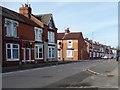
1
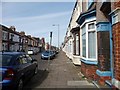
Abingdon Road, Middlesbrough
Heading north from Victoria Road. Victorian Middlesbrough was developed in grid irons of parallel terraced streets.
Image: © Christine Johnstone
Taken: 2 Apr 2015
0.02 miles
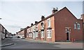
2
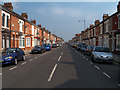
Abingdon Road
A shot of the full length of Abingdon Road looking northwards towards Borough Road in the distance
Image: © Mike Guess
Taken: 8 Jun 2006
0.06 miles
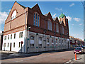
3
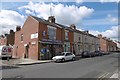
Geo Food Store
Waterloo Road, Middlesbrough
Image: © Richard Webb
Taken: 10 Aug 2016
0.08 miles
4
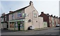
Mahmood & Sons Halal Butchers, Middlesbrough
At the junction of Waterloo Road and Falmouth Street.
Image: © Christine Johnstone
Taken: 2 Apr 2015
0.09 miles
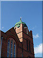
5
Jamia Mosque
Mosque on Waterloo Road
Image: © Stephen McCulloch
Taken: 15 Apr 2008
0.09 miles
7
Roscoe Street, Middlesbrough
A few to let signs, it's Summer and the students are away.
Image: © Richard Webb
Taken: 10 Aug 2016
0.10 miles
8
Falmouth Street, Middlesbrough
Running north from Park Avenue. Victorian Middlesbrough was developed in grid irons of parallel terraced streets.
Image: © Christine Johnstone
Taken: 2 Apr 2015
0.12 miles
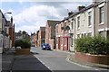
9
Abingdon Road near the junction with Clarendon Road
Part of cycle route 65.
Image: © Christine Johnstone
Taken: 2 Apr 2015
0.12 miles
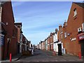
10
Clarendon Road, Middlesbrough
Running west from Abingdon Road. Victorian Middlesbrough was developed in a grid iron of parallel terraced streets.
Image: © Christine Johnstone
Taken: 2 Apr 2015
0.13 miles