IMAGES TAKEN NEAR TO
Mickleby, SALTBURN-BY-THE-SEA, TS13 5NB
Introduction
This page details the photographs taken nearby to TS13 5NB by members of the Geograph project.
The Geograph project started in 2005 with the aim of publishing, organising and preserving representative images for every square kilometre of Great Britain, Ireland and the Isle of Man.

There are currently over 7.5m images from over14,400 individuals and you can help contribute to the project by visiting https://www.geograph.org.uk
Image Map (Loading...)


Getting Data...Please wait
Leaflet Map data © OpenStreetMap
Images are licensed for reuse under creativecommons.org/licenses/by-sa/2.0
Notes
- Clicking on the map will re-center to the selected point.
- The higher the marker number, the further away the image location is from the centre of the postcode.
Image Listing (13 Images Found)
Images are licensed for reuse under creativecommons.org/licenses/by-sa/2.0
Image
Details
Distance
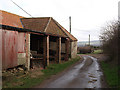
2
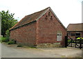
Unusual design for barn
This barn looks crazy to me, the roof line is all over the place. I suppose there must have been some reason for it when it was originally built but it completely eludes me.
Image: © mike
Taken: 20 Jun 2014
0.01 miles
4
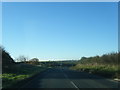
Junction of B1266 and A174
Taken from the corner of the B1266 and the Mickleby road
Image: © Stephen McCulloch
Taken: 14 Feb 2008
0.16 miles
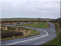
6
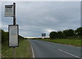
Bus stop along the A174 at Mickleby Hole
Image: © Mat Fascione
Taken: 10 Aug 2018
0.19 miles
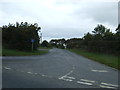
7
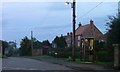
Telephone Box, Mickleby
Taken after sunset at the junction of the no through road to Low Farm.
Image: © Mick Garratt
Taken: 15 Aug 2006
0.20 miles