IMAGES TAKEN NEAR TO
The Lane, SALTBURN-BY-THE-SEA, TS13 5LT
Introduction
This page details the photographs taken nearby to The Lane, TS13 5LT by members of the Geograph project.
The Geograph project started in 2005 with the aim of publishing, organising and preserving representative images for every square kilometre of Great Britain, Ireland and the Isle of Man.

There are currently over 7.5m images from over14,400 individuals and you can help contribute to the project by visiting https://www.geograph.org.uk
Image Map (Loading...)


Getting Data...Please wait
Leaflet Map data © OpenStreetMap
Images are licensed for reuse under creativecommons.org/licenses/by-sa/2.0
Notes
- Clicking on the map will re-center to the selected point.
- The higher the marker number, the further away the image location is from the centre of the postcode.
Image Listing (6 Images Found)
Images are licensed for reuse under creativecommons.org/licenses/by-sa/2.0
Image
Details
Distance
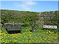
1
Commemorative seat at Mickleby
On entering the village on Mickleby Lane
Image: © Martin Dawes
Taken: 17 Apr 2013
0.06 miles
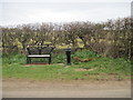
2
Water pump and bench
Water pump and bench at the western end of Mickleby.
Image: © T Eyre
Taken: 1 May 2021
0.06 miles
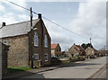
3
Entering Mickleby from Mickleby Lane
It becomes, The Lane as it goes through the village.
Image: © Martin Dawes
Taken: 17 Apr 2013
0.09 miles
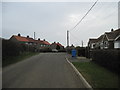
4
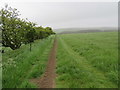
Footpath near Mickleby
Looking towards Ugthorpe.
Image: © T Eyre
Taken: 7 May 2017
0.21 miles