IMAGES TAKEN NEAR TO
Sunny Row, SALTBURN-BY-THE-SEA, TS13 5LA
Introduction
This page details the photographs taken nearby to Sunny Row, TS13 5LA by members of the Geograph project.
The Geograph project started in 2005 with the aim of publishing, organising and preserving representative images for every square kilometre of Great Britain, Ireland and the Isle of Man.

There are currently over 7.5m images from over14,400 individuals and you can help contribute to the project by visiting https://www.geograph.org.uk
Image Map (Loading...)


Getting Data...Please wait
Leaflet Map data © OpenStreetMap
Images are licensed for reuse under creativecommons.org/licenses/by-sa/2.0
Notes
- Clicking on the map will re-center to the selected point.
- The higher the marker number, the further away the image location is from the centre of the postcode.
Image Listing (54 Images Found)
Images are licensed for reuse under creativecommons.org/licenses/by-sa/2.0
Image
Details
Distance
1
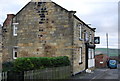
Ship Inn, Port Mulgrave
Inn, in an old mining village
Image: © N Chadwick
Taken: 30 Dec 2007
0.02 miles
3
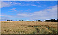
A field seen from Rosedale Lane, Port Mulgrave
Image: © habiloid
Taken: 25 Jul 2022
0.10 miles
4
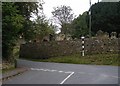
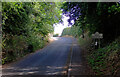
Rosedale Lane, Hinderwell
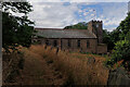
Rosedale Lane comes into Hinderwell from Port Mulgrave (earlier name Port Rosedale) and here it makes a junction with the original alignment of the Whitby to Loftus Road (now A174). Beyond the junction is a nicely looked after survival of a cast iron finger post and beyond that the massive retaining wall to the churchyard of St Hilda's. The new alignment of the A174 is on the other side of the churchyard. The retaining wall is a Listed Building, Grade II.
Image: © Christopher Hall
Taken: 14 Sep 2014
0.13 miles
5

Footpath leaving Old High Street, Hinderwell
Image: © habiloid
Taken: 25 Jul 2022
0.13 miles
6
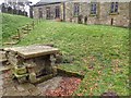
St. Hilda's Well
From whence the name "Hinderwell" derives.
Image: © Mick Garratt
Taken: 5 Mar 2015
0.13 miles
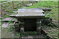
8
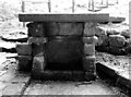
St. Hilda's Well, Hinderwell
The inscription on the wall reads:
"St Hilda's Well
Restored By
Hilda Palmer
Of Grinkle Park
1912".
Image: © habiloid
Taken: 25 Jul 2022
0.13 miles
9
St. Hilda's Well, Hinderwell
Gives its name to the village of Hinderwell, and located in the churchyard.
The water is said to have healing properties, associated with St. Hilda the abbess who founded the monastery at Whitby in the 7th Century.
Image: © Chris Heaton
Taken: 10 Sep 2018
0.13 miles