IMAGES TAKEN NEAR TO
Bank Top Lane, SALTBURN-BY-THE-SEA, TS13 5JF
Introduction
This page details the photographs taken nearby to Bank Top Lane, TS13 5JF by members of the Geograph project.
The Geograph project started in 2005 with the aim of publishing, organising and preserving representative images for every square kilometre of Great Britain, Ireland and the Isle of Man.

There are currently over 7.5m images from over14,400 individuals and you can help contribute to the project by visiting https://www.geograph.org.uk
Image Map (Loading...)


Getting Data...Please wait
Leaflet Map data © OpenStreetMap
Images are licensed for reuse under creativecommons.org/licenses/by-sa/2.0
Notes
- Clicking on the map will re-center to the selected point.
- The higher the marker number, the further away the image location is from the centre of the postcode.
Image Listing (190 Images Found)
Images are licensed for reuse under creativecommons.org/licenses/by-sa/2.0
Image
Details
Distance
1

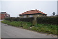
Runswick Bay Public Comveniences
The Car Park in Bank Top Lane.
Image: © Ian Rob
Taken: 10 Sep 2021
0.02 miles
2
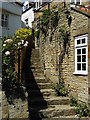
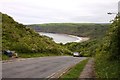
Houses at Runswick Bay
Runswick is a small village of closely spaced dwellings built on the steep slope, adjoined by twisting patchs and steps.
Image: © Alan Hood
Taken: Unknown
0.03 miles
5
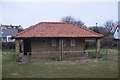
Public Toilets & Car Park, Runswick Bank Top
Image: © Mick Garratt
Taken: 10 Dec 2005
0.05 miles
6
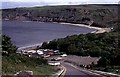
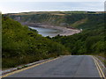
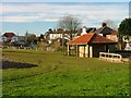
View of Runswick Bay
From viewpoint over the village
Image: © Stanley Howe
Taken: Unknown
0.05 miles