IMAGES TAKEN NEAR TO
Moor View, SALTBURN-BY-THE-SEA, TS13 5HH
Introduction
This page details the photographs taken nearby to Moor View, TS13 5HH by members of the Geograph project.
The Geograph project started in 2005 with the aim of publishing, organising and preserving representative images for every square kilometre of Great Britain, Ireland and the Isle of Man.

There are currently over 7.5m images from over14,400 individuals and you can help contribute to the project by visiting https://www.geograph.org.uk
Image Map (Loading...)


Getting Data...Please wait
Leaflet Map data © OpenStreetMap
Images are licensed for reuse under creativecommons.org/licenses/by-sa/2.0
Notes
- Clicking on the map will re-center to the selected point.
- The higher the marker number, the further away the image location is from the centre of the postcode.
Image Listing (16 Images Found)
Images are licensed for reuse under creativecommons.org/licenses/by-sa/2.0
Image
Details
Distance
1
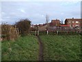
Footpath to Hinderwell
Footpath leading from Back Lane to the High Street
Image: © Stephen McCulloch
Taken: 27 Nov 2007
0.04 miles
5
Hinderwell railway station (site), Yorkshire
Opened in 1883 on the North Eastern Railway's line from Redcar to Whitby, this station closed in 1958. View east from the former level crossing - one of the gate posts (behind the camera) was still there when this image was taken. Other than some street names, it is the only trace of a former railway use for this site.
Image: © Nigel Thompson
Taken: 10 Oct 2009
0.11 miles
6

Site of Hinderwell station, 1997
View NW on entering Hinderwell on the A174 road, towards Loftus and Middlesbrough: ex-NE Whitby - Loftus - Middlesbrough line. The station was on the left and closed 5/5/58 with the line Whitby West Cliff - Loftus: Loftus - Saltburn/Middlesbrough closed from 30/5/60 (passengers), goods 10/8/63 - but has been restored for potash traffic from Skinningrove since 1/4/74.
Image: © Ben Brooksbank
Taken: 24 Jun 1997
0.13 miles
7
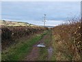
Back Lane, Hinderwell
Track to the south of the village
Image: © Stephen McCulloch
Taken: 27 Nov 2007
0.13 miles
8
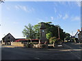
Hinderwell memorial.
A short walk from Runswick bay.
Image: © steven ruffles
Taken: 27 Jun 2015
0.14 miles
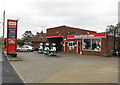
9
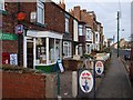
Hinderwell post office
Shop and post office situated on the High Street
Image: © Stephen McCulloch
Taken: 27 Nov 2007
0.14 miles
