IMAGES TAKEN NEAR TO
Borrowby, SALTBURN-BY-THE-SEA, TS13 5EJ
Introduction
This page details the photographs taken nearby to TS13 5EJ by members of the Geograph project.
The Geograph project started in 2005 with the aim of publishing, organising and preserving representative images for every square kilometre of Great Britain, Ireland and the Isle of Man.

There are currently over 7.5m images from over14,400 individuals and you can help contribute to the project by visiting https://www.geograph.org.uk
Image Map
Images are licensed for reuse under creativecommons.org/licenses/by-sa/2.0
Notes
- Clicking on the map will re-center to the selected point.
- The higher the marker number, the further away the image location is from the centre of the postcode.
Image Listing (12 Images Found)
Images are licensed for reuse under creativecommons.org/licenses/by-sa/2.0
Image
Details
Distance
1
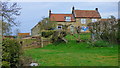
Plum Tree Farm
View from footpath to Plum Tree Farm south east of Dalehouse
Image: © Malcolm Coils
Taken: 1 Apr 2019
0.01 miles
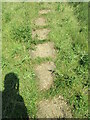
2
Stone trod near Plum Tree House 2
More flagstone south of Plum Tree House.
Image: © T Eyre
Taken: 18 Aug 2021
0.06 miles
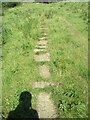
3
Stone trod near Plum Tree House
A short stretch of flagstones south of Plum Tree House.
Image: © T Eyre
Taken: 18 Aug 2021
0.09 miles
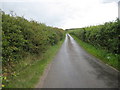
5
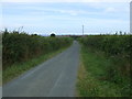
Borrowby Lane
Heading north east towards Dalehouse.
Image: © JThomas
Taken: 26 Jul 2015
0.17 miles
6
Borrowby Lane
Heading north east towards Dalehouse.
Image: © JThomas
Taken: 26 Jul 2015
0.19 miles
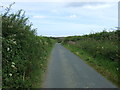
7
Borrowby Lane near Cooper House
This photograph shows a view of Borrowby Lane as it approaches Dalehouse from the direction of Borrowby (ahead). Keld Hill can be seen on the horizon in the right-hand side of the image. The picture was taken looking in a south-south-westerly direction towards Borrowby.
Image: © Philip Barker
Taken: 1 Aug 2010
0.20 miles
8
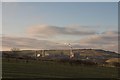
Boulby Mine from near Borrowby
Looking North West to Boulby mine from the Borrowby to Dalehouse road.
Good example of rig and furrow medieval ploughing in the grassland foreground.
Image: © Colin Grice
Taken: 29 Jan 2006
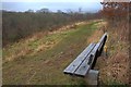
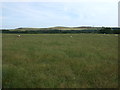
0.23 miles
9
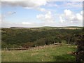
Oakrigg Wood
View from top of valley down onto Oakrigg Wood.
Image: © Darren Haddock
Taken: 23 Aug 2006
0.23 miles