IMAGES TAKEN NEAR TO
Staithes, SALTBURN-BY-THE-SEA, TS13 5EA
Introduction
This page details the photographs taken nearby to TS13 5EA by members of the Geograph project.
The Geograph project started in 2005 with the aim of publishing, organising and preserving representative images for every square kilometre of Great Britain, Ireland and the Isle of Man.

There are currently over 7.5m images from over14,400 individuals and you can help contribute to the project by visiting https://www.geograph.org.uk
Image Map
Images are licensed for reuse under creativecommons.org/licenses/by-sa/2.0
Notes
- Clicking on the map will re-center to the selected point.
- The higher the marker number, the further away the image location is from the centre of the postcode.
Image Listing (6 Images Found)
Images are licensed for reuse under creativecommons.org/licenses/by-sa/2.0
Image
Details
Distance
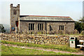
1
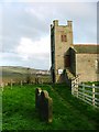
St. Nicholas' Church, Roxby
In the distance can be seen the potash mine at Boultby.
Image: © Mick Garratt
Taken: 13 Nov 2005
0.19 miles
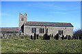
2
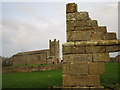
St. Nicholas Church and ruin of Roxby Hall
The remaining ruined corner of 13th Century Roxby Hall, with St. Nicholas Church in the background.
Image: © Chris Twigg
Taken: 2 May 2006
0.22 miles
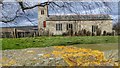
6
St Nicolas Church, Roxby
For some more details about the Church see:
http://www.boyntons.us/yorkshire/places/roxby/church/churchdrawing.html
Image: © Michael Jagger
Taken: 13 Mar 2010
0.24 miles