IMAGES TAKEN NEAR TO
Cliff Road, SALTBURN-BY-THE-SEA, TS13 5AF
Introduction
This page details the photographs taken nearby to Cliff Road, TS13 5AF by members of the Geograph project.
The Geograph project started in 2005 with the aim of publishing, organising and preserving representative images for every square kilometre of Great Britain, Ireland and the Isle of Man.

There are currently over 7.5m images from over14,400 individuals and you can help contribute to the project by visiting https://www.geograph.org.uk
Image Map
Images are licensed for reuse under creativecommons.org/licenses/by-sa/2.0
Notes
- Clicking on the map will re-center to the selected point.
- The higher the marker number, the further away the image location is from the centre of the postcode.
Image Listing (12 Images Found)
Images are licensed for reuse under creativecommons.org/licenses/by-sa/2.0
Image
Details
Distance
2
Staithes Camp
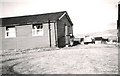
A one time "holiday camp" where groups of young people stayed. We slept in bunk beds in communal huts. Girls and boys were well segregated.
Image: © Gerald England
Taken: Unknown
0.09 miles
3

Crop at Cliff Farm
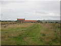
The coastal path leaves Staithes and passes through some arable land on its way towards Beacon Hill (behind). It was the third week of September and it appeared that the crop had not long been harvested.
Image: © Graham Horn
Taken: 22 Sep 2011
0.12 miles
7
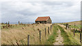
Small barn beside Cleveland Way
The barn lies to the east of Greenacres Farm, close to Staithes.
Image: © Trevor Littlewood
Taken: 21 Aug 2020
0.20 miles
8
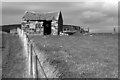
Derelict barn near Stiathes
This barn lies on the Cleveland Way east of Staithes.
Image: © habiloid
Taken: 14 Sep 2010
0.20 miles
9
Coastal path south of Staithes
Part of Cleveland Way National Trail
Image: © Dave Eagle
Taken: 17 May 2004
0.20 miles
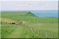
10

Coastal path up to Beacon Hill
These walkers taking the direct route up are finding the going tough. We can see how steep it is. I took the longer flatter route, closer to the coast, and reached the top before them.
Image: © Graham Horn
Taken: 22 Sep 2011
0.24 miles