IMAGES TAKEN NEAR TO
Ash Grove, SALTBURN-BY-THE-SEA, TS13 4XA
Introduction
This page details the photographs taken nearby to Ash Grove, TS13 4XA by members of the Geograph project.
The Geograph project started in 2005 with the aim of publishing, organising and preserving representative images for every square kilometre of Great Britain, Ireland and the Isle of Man.

There are currently over 7.5m images from over14,400 individuals and you can help contribute to the project by visiting https://www.geograph.org.uk
Image Map (Loading...)


Getting Data...Please wait
Leaflet Map data © OpenStreetMap
Images are licensed for reuse under creativecommons.org/licenses/by-sa/2.0
Notes
- Clicking on the map will re-center to the selected point.
- The higher the marker number, the further away the image location is from the centre of the postcode.
Image Listing (35 Images Found)
Images are licensed for reuse under creativecommons.org/licenses/by-sa/2.0
Image
Details
Distance
1
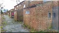
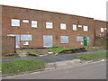
Derelict Housing Estate
Built in the mid 1970s. One of my first jobs after moving into the area.
Image: © Mick Garratt
Taken: 21 Dec 2014
0.05 miles
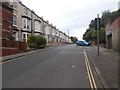
3
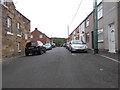
Houses for demolition, Westfield Terrace, Loftus
Image: © Alex McGregor
Taken: 27 Jan 2011
0.06 miles
4
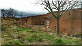
Derelict Housing Estate
Built in the mid 1970s. One of my first jobs after moving into the area.
Image: © Mick Garratt
Taken: 21 Dec 2014
0.06 miles
7
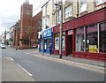
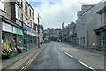
Road junction in Loftus, North Yorkshire
Of Zetland Road and Stanon Road.
Image: © James Denham
Taken: 29 Jul 2014
0.11 miles
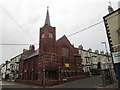
8
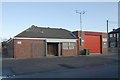
Loftus fire station
Loftus fire station, Coronation Road, Loftus, Cleveland
Image: © Kevin Hale
Taken: 27 Nov 2006
0.11 miles