IMAGES TAKEN NEAR TO
Loftus, SALTBURN-BY-THE-SEA, TS13 4TY
Introduction
This page details the photographs taken nearby to TS13 4TY by members of the Geograph project.
The Geograph project started in 2005 with the aim of publishing, organising and preserving representative images for every square kilometre of Great Britain, Ireland and the Isle of Man.

There are currently over 7.5m images from over14,400 individuals and you can help contribute to the project by visiting https://www.geograph.org.uk
Image Map (Loading...)


Getting Data...Please wait
Leaflet Map data © OpenStreetMap
Images are licensed for reuse under creativecommons.org/licenses/by-sa/2.0
Notes
- Clicking on the map will re-center to the selected point.
- The higher the marker number, the further away the image location is from the centre of the postcode.
Image Listing (3 Images Found)
Images are licensed for reuse under creativecommons.org/licenses/by-sa/2.0
Image
Details
Distance
1
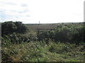
Overgrown footbridge and stile near Low Waupley
Image: © John Slater
Taken: 11 Sep 2018
0.15 miles
2
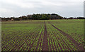
Field with emerging crop near Low Waupley
The image was recorded from a public footpath crossing the field; no attempt had been made to reinstate the line of the right of way once planting had been completed.
Image: © Trevor Littlewood
Taken: 14 Oct 2011
0.18 miles
3
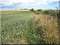
Ripening crops near Low Waupley
This photograph shows a view of a field of ripening summer crops near Low Waupley. The public footpath that runs between High Waupley and Low Waupley is just visible running along the side of the field. The picture was taken looking in a north-north-easterly direction towards High Waupley (just visible on the horizon in the centre of the image).
Image: © Philip Barker
Taken: 1 Aug 2010
0.22 miles