IMAGES TAKEN NEAR TO
Loftus, SALTBURN-BY-THE-SEA, TS13 4SY
Introduction
This page details the photographs taken nearby to TS13 4SY by members of the Geograph project.
The Geograph project started in 2005 with the aim of publishing, organising and preserving representative images for every square kilometre of Great Britain, Ireland and the Isle of Man.

There are currently over 7.5m images from over14,400 individuals and you can help contribute to the project by visiting https://www.geograph.org.uk
Image Map (Loading...)


Getting Data...Please wait
Leaflet Map data © OpenStreetMap
Images are licensed for reuse under creativecommons.org/licenses/by-sa/2.0
Notes
- Clicking on the map will re-center to the selected point.
- The higher the marker number, the further away the image location is from the centre of the postcode.
Image Listing (6 Images Found)
Images are licensed for reuse under creativecommons.org/licenses/by-sa/2.0
Image
Details
Distance
1
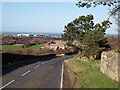
Approaching Liverton Mines
Heading north on the B1366.
Steelworks at Carlin How can be seen in the distance.
Image: © Stephen McCulloch
Taken: 6 Feb 2008
0.14 miles
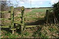
2
End of Footpath From Park House Farm
Just at its junction with Liverton Road.
Image: © Mick Garratt
Taken: 5 Mar 2008
0.16 miles
3
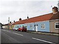
Terraced houses - Liverton Mines
Terraced houses in Liverton Mines, presumably built originally to accommodate local workers in the iron and steel mining and smelting industry.
Image: © Colin Grice
Taken: 29 Jan 2006
0.20 miles
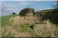
4
Stile Near Butts Cottage
On the footpath from Park House Farm.
Image: © Mick Garratt
Taken: 5 Mar 2008
0.20 miles
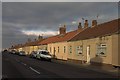
5
Liverton Mines Houses
Neat cottages line both sides of the road.
Image: © Ian Rob
Taken: 10 Sep 2021
0.23 miles
6
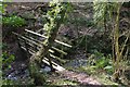
Bridge Over Holygill Beck
Not sure if this really is called Holygill Beck but it flow from Holygill Well near Liverton church.
Image: © Mick Garratt
Taken: 5 Mar 2008
0.24 miles