IMAGES TAKEN NEAR TO
North Terrace, SALTBURN-BY-THE-SEA, TS13 4JG
Introduction
This page details the photographs taken nearby to North Terrace, TS13 4JG by members of the Geograph project.
The Geograph project started in 2005 with the aim of publishing, organising and preserving representative images for every square kilometre of Great Britain, Ireland and the Isle of Man.

There are currently over 7.5m images from over14,400 individuals and you can help contribute to the project by visiting https://www.geograph.org.uk
Image Map
Images are licensed for reuse under creativecommons.org/licenses/by-sa/2.0
Notes
- Clicking on the map will re-center to the selected point.
- The higher the marker number, the further away the image location is from the centre of the postcode.
Image Listing (11 Images Found)
Images are licensed for reuse under creativecommons.org/licenses/by-sa/2.0
Image
Details
Distance
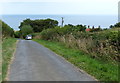
1
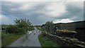
Geese crossing
At Spring House farm on the road to Boulby from Skinningrove.
Image: © Steve Fareham
Taken: 14 May 2011
0.06 miles
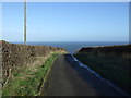
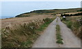
2
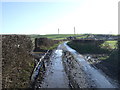
A muddy lane
Heading east near Spring House Farm.
Image: © JThomas
Taken: 8 Feb 2014
0.09 miles
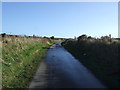
4
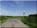
Road Junction
Road junction near to Skinningrove, North Yorkshire.
Image: © Keith Evans
Taken: 3 Jun 2010
0.18 miles
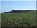
7
Hummersea Farm and English Coast Path: aerial 2018
Image: © Chris
Taken: 4 Jul 2018
0.21 miles
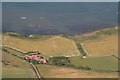
10
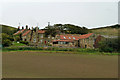
Hummersea and Warsett Farms
The closer buildings are Warsett Farm. Behind, across a lane, is Hummersea Farm.
Image: © Robin Webster
Taken: 8 Oct 2011
0.23 miles