IMAGES TAKEN NEAR TO
Sanderson Grove, SALTBURN-BY-THE-SEA, TS13 4GB
Introduction
This page details the photographs taken nearby to Sanderson Grove, TS13 4GB by members of the Geograph project.
The Geograph project started in 2005 with the aim of publishing, organising and preserving representative images for every square kilometre of Great Britain, Ireland and the Isle of Man.

There are currently over 7.5m images from over14,400 individuals and you can help contribute to the project by visiting https://www.geograph.org.uk
Image Map
Images are licensed for reuse under creativecommons.org/licenses/by-sa/2.0
Notes
- Clicking on the map will re-center to the selected point.
- The higher the marker number, the further away the image location is from the centre of the postcode.
Image Listing (22 Images Found)
Images are licensed for reuse under creativecommons.org/licenses/by-sa/2.0
Image
Details
Distance
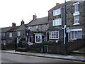
1
Victoria Terrace (A174), Loftus
Heading west.
Image: © JThomas
Taken: 8 Feb 2014
0.03 miles
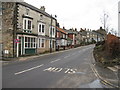
2
Service Station, Loftus
On Victoria Terrace (A174).
Image: © JThomas
Taken: 8 Feb 2014
0.07 miles
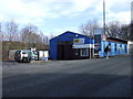
7

Loftus bus depot
Arriva bus depot at Loftus.
Update: This depot closed in January 2009.
Image: © Stephen McCulloch
Taken: 16 Oct 2007
0.12 miles
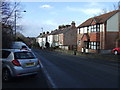
8
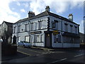
The Royal pub, East Loftus
Currently boarded up (Feb. 2014).
On Whitby Road.
Image: © JThomas
Taken: 8 Feb 2014
0.15 miles