IMAGES TAKEN NEAR TO
Wesley Terrace, SALTBURN-BY-THE-SEA, TS13 4EG
Introduction
This page details the photographs taken nearby to Wesley Terrace, TS13 4EG by members of the Geograph project.
The Geograph project started in 2005 with the aim of publishing, organising and preserving representative images for every square kilometre of Great Britain, Ireland and the Isle of Man.

There are currently over 7.5m images from over14,400 individuals and you can help contribute to the project by visiting https://www.geograph.org.uk
Image Map (Loading...)


Getting Data...Please wait
Leaflet Map data © OpenStreetMap
Images are licensed for reuse under creativecommons.org/licenses/by-sa/2.0
Notes
- Clicking on the map will re-center to the selected point.
- The higher the marker number, the further away the image location is from the centre of the postcode.
Image Listing (65 Images Found)
Images are licensed for reuse under creativecommons.org/licenses/by-sa/2.0
Image
Details
Distance
1
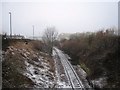
Railway track at Carlin How
This photograph shows a view of the single-track railway that runs between Saltburn and Boulby Potash Mine. The Corus works at Carlin How can just be seen in the background of the picture on the right-hand side of the railway. Some of the houses in the village (and the road sign for Kilton) can be seen on the left of the image. The picture was taken during a snow storm looking in a north-westerly direction towards Gripps Farm.
Image: © Philip Barker
Taken: 21 Feb 2010
0.06 miles
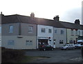
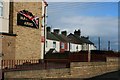
4
Street at Carlin How
One of the terraced streets at Carlin How. This one is distinctive for having a row of coal sheds opposite the house fronts.
Image: © Stephen McCulloch
Taken: 16 Oct 2007
0.09 miles
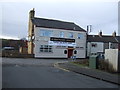
7
Maynard Arms
The Union Jack said "British n' Proud"
Image: © Mick Garratt
Taken: 13 Feb 2007
0.10 miles
8
All quiet at British Steel Skinningrove's works
Potentially could be saved by a Turkish military pension fund.
See https://www.theguardian.com/business/2019/aug/08/british-steel-talks-with-potential-buyer-imminent-leadsom
Image: © Mick Garratt
Taken: 25 Aug 2019
0.11 miles
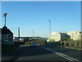
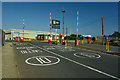
9
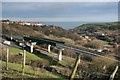
Railway Bridge
New railway bridge, dating from the early 1970s, carrying the mineral line to Boulby Potash Mine over the A174 climbing up Carlin How bank. Skinningrove lies in the valley.
The embankment and bridge over a much narrower A174 which this bridge replaced can be seen at http://www.disused-stations.org.uk/s/skinningrove/index9.shtml (Skinningrove station was just to the right of the photographer's location.)
Image: © Mick Garratt
Taken: 13 Feb 2007
0.11 miles
10
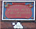
Sign for Carlin How & District Working Mens Club & Institute
Image: © JThomas
Taken: 8 Feb 2014
0.12 miles