IMAGES TAKEN NEAR TO
Carlin How, SALTBURN-BY-THE-SEA, TS13 4AQ
Introduction
This page details the photographs taken nearby to TS13 4AQ by members of the Geograph project.
The Geograph project started in 2005 with the aim of publishing, organising and preserving representative images for every square kilometre of Great Britain, Ireland and the Isle of Man.

There are currently over 7.5m images from over14,400 individuals and you can help contribute to the project by visiting https://www.geograph.org.uk
Image Map (Loading...)


Getting Data...Please wait
Leaflet Map data © OpenStreetMap
Images are licensed for reuse under creativecommons.org/licenses/by-sa/2.0
Notes
- Clicking on the map will re-center to the selected point.
- The higher the marker number, the further away the image location is from the centre of the postcode.
Image Listing (62 Images Found)
Images are licensed for reuse under creativecommons.org/licenses/by-sa/2.0
Image
Details
Distance
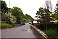
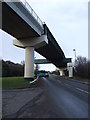
1
Railway Bridge
New railway bridge, dating from the early 1970s, carrying the mineral line to Boulby Potash Mine over the A174 climbing up Carlin How bank. Skinningrove lies in the valley.
The embankment and bridge over a much narrower A174 which this bridge replaced can be seen at http://www.disused-stations.org.uk/s/skinningrove/index9.shtml (Skinningrove station was just to the right of the photographer's location.)
Image: © Mick Garratt
Taken: 13 Feb 2007
0.06 miles
4
Railway bridge over Mill Bank
The mineral line from Boulby Mine.
Image: © JThomas
Taken: 8 Feb 2014
0.09 miles
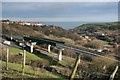
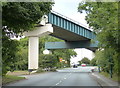
5

Railway bridge over A174
This bridge carries the railway line to Boulby potash mine over the A174 road near the valley of Skinningrove Beck. Looking up the A174 towards Carlin How.
Image: © Stephen McCulloch
Taken: 16 Oct 2007
0.09 miles
6
Railway bridge across the A174 Mill Bank
Image: © Mat Fascione
Taken: 9 Aug 2018
0.10 miles
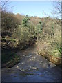
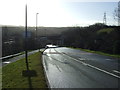
9
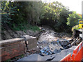
Flood Damage Skinningrove
Not surprisingly this road is closed.After the heavy rain on Friday 6/9/13 the flood water damaged the bank and the wall and road edge fell in.
Image: © Martin Dawes
Taken: 9 Oct 2013
0.11 miles