IMAGES TAKEN NEAR TO
Moor Close, SALTBURN-BY-THE-SEA, TS12 3JS
Introduction
This page details the photographs taken nearby to Moor Close, TS12 3JS by members of the Geograph project.
The Geograph project started in 2005 with the aim of publishing, organising and preserving representative images for every square kilometre of Great Britain, Ireland and the Isle of Man.

There are currently over 7.5m images from over14,400 individuals and you can help contribute to the project by visiting https://www.geograph.org.uk
Image Map
Images are licensed for reuse under creativecommons.org/licenses/by-sa/2.0
Notes
- Clicking on the map will re-center to the selected point.
- The higher the marker number, the further away the image location is from the centre of the postcode.
Image Listing (10 Images Found)
Images are licensed for reuse under creativecommons.org/licenses/by-sa/2.0
Image
Details
Distance
1
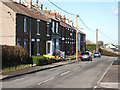
Terrace at Moorsholm
The old post office in the centre of the terrace has closed and moved to a building a little down the road. This in turn is earmarked for closure.
Image: © Stephen McCulloch
Taken: 6 Feb 2008
0.08 miles
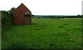
2
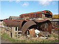
Corrugated storage shed
At Lodge Farm. Has seen better days.
Image: © Stephen McCulloch
Taken: 6 Feb 2008
0.09 miles
3
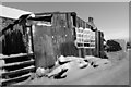
Fred's Shed, The Grange, Moorsholm
Snow bound shed to the rear of The Grange, Moorsholm.
Image: © Lisa S Metcalfe
Taken: 20 Dec 2009
0.10 miles
4
Sheep Pasture, Lodge Farm
Off Cow Gate Close. Freebrough Hill is partially hidden behind the tree at the far end of the field.
Image: © Mick Garratt
Taken: 24 Jun 2006
0.13 miles
5
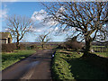
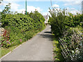
Cow Close Lane
Taken from near Lodge Farm, looking east.
Image: © Stephen McCulloch
Taken: 6 Feb 2008
0.14 miles
7
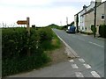
Freeborough road, Moorsholm
Taken from the junction with Cow Close Lane. The conical Freebrough Hill can be seen at the end of the road.
Image: © Mick Garratt
Taken: 24 Jun 2006
0.19 miles
8
Former Industrial Building Used as a Barn...
... in a field at the corner of Cow Close lane and Freeborough Road.
Image: © Mick Garratt
Taken: 24 Jun 2006
0.19 miles
10
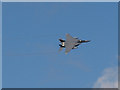
One for the plane-spotters
Four of these flew over to the north of Cow Close Lane.
After a bit of surfing, I think that it is an F-15 fighter.
Whatever it is, it looks like it means business.
Image: © Stephen McCulloch
Taken: 6 Feb 2008
0.25 miles