IMAGES TAKEN NEAR TO
Kilton Lane, SALTBURN-BY-THE-SEA, TS12 3EG
Introduction
This page details the photographs taken nearby to Kilton Lane, TS12 3EG by members of the Geograph project.
The Geograph project started in 2005 with the aim of publishing, organising and preserving representative images for every square kilometre of Great Britain, Ireland and the Isle of Man.

There are currently over 7.5m images from over14,400 individuals and you can help contribute to the project by visiting https://www.geograph.org.uk
Image Map (Loading...)


Getting Data...Please wait
Leaflet Map data © OpenStreetMap
Images are licensed for reuse under creativecommons.org/licenses/by-sa/2.0
Notes
- Clicking on the map will re-center to the selected point.
- The higher the marker number, the further away the image location is from the centre of the postcode.
Image Listing (16 Images Found)
Images are licensed for reuse under creativecommons.org/licenses/by-sa/2.0
Image
Details
Distance

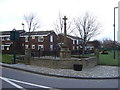
10
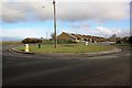
Roundabout near Lingdale Industrial Estate
This photograph shows a view of the roundabout near the industrial estate at the south-east-end of the village of Lingdale. Little Moorsholm Lane can just be seen in front of the gate in the left-hand side of the image. The picture was taken looking in a north-easterly direction towards Liverton Mines.
Image: © Philip Barker
Taken: 27 Feb 2010
0.10 miles