IMAGES TAKEN NEAR TO
Rievaulx Road, SALTBURN-BY-THE-SEA, TS12 2YP
Introduction
This page details the photographs taken nearby to Rievaulx Road, TS12 2YP by members of the Geograph project.
The Geograph project started in 2005 with the aim of publishing, organising and preserving representative images for every square kilometre of Great Britain, Ireland and the Isle of Man.

There are currently over 7.5m images from over14,400 individuals and you can help contribute to the project by visiting https://www.geograph.org.uk
Image Map
Images are licensed for reuse under creativecommons.org/licenses/by-sa/2.0
Notes
- Clicking on the map will re-center to the selected point.
- The higher the marker number, the further away the image location is from the centre of the postcode.
Image Listing (3 Images Found)
Images are licensed for reuse under creativecommons.org/licenses/by-sa/2.0
Image
Details
Distance
1
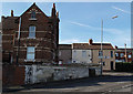
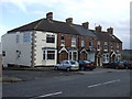
Older part of New Skelton
Terraced houses at William Street, on the southern side of the main road.
These would have been built to house miners from the local ironstone mines.
The house on the left is larger with more ornate brickwork and may have housed mine management.
Image: © Stephen McCulloch
Taken: 12 Nov 2007
0.15 miles
3
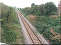
North Skelton railway station (site), Yorkshire
Opened in 1902 by the North Eastern Railway on its line from Saltburn to Whitby, this station closed in 1951. View south east from Watness Avenue bridge. The former station house is hidden in the trees to the right.
Image: © Nigel Thompson
Taken: 10 Oct 2009
0.23 miles