IMAGES TAKEN NEAR TO
High Street, SALTBURN-BY-THE-SEA, TS12 2LF
Introduction
This page details the photographs taken nearby to High Street, TS12 2LF by members of the Geograph project.
The Geograph project started in 2005 with the aim of publishing, organising and preserving representative images for every square kilometre of Great Britain, Ireland and the Isle of Man.

There are currently over 7.5m images from over14,400 individuals and you can help contribute to the project by visiting https://www.geograph.org.uk
Image Map
Images are licensed for reuse under creativecommons.org/licenses/by-sa/2.0
Notes
- Clicking on the map will re-center to the selected point.
- The higher the marker number, the further away the image location is from the centre of the postcode.
Image Listing (24 Images Found)
Images are licensed for reuse under creativecommons.org/licenses/by-sa/2.0
Image
Details
Distance
1
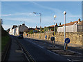
High Street, Skelton
Looking west from just beyond the junction with Saltburn Lane.
The tower of All Saints Church can be made out above the far houses.
Image: © Stephen McCulloch
Taken: 12 Nov 2007
0.01 miles
2
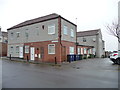
Marlborough Court, Skelton, from the south-east
A First World War Drill Hall that has been converted to housing.
Image: © Christine Johnstone
Taken: 3 Apr 2015
0.03 miles
3
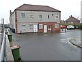
Marlborough Court, Skelton, from the south-west
Skelton's former First World War drill hall, now converted to housing.
Image: © Christine Johnstone
Taken: 3 Apr 2015
0.04 miles
4
Marlborough Court, Skelton, west side
A First World War Drill Hall that has been converted to housing.
Image: © Christine Johnstone
Taken: 3 Apr 2015
0.04 miles
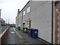
5
![Robinson Street, Skelton [2]](https://s3.geograph.org.uk/geophotos/04/42/62/4426267_cfbd01c5_120x120.jpg)
Robinson Street, Skelton [2]
North side of High Street. The east side of the houses.
Image: © Christine Johnstone
Taken: 3 Apr 2015
0.04 miles
6
![Robinson Street, Skelton [1]](https://s0.geograph.org.uk/geophotos/04/42/62/4426244_54798f9e_120x120.jpg)
Robinson Street, Skelton [1]
On the north side of the High Street, at the east end of the churchyard. The west side of the houses.
Image: © Christine Johnstone
Taken: 3 Apr 2015
0.05 miles
7
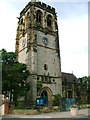
All Saints' Church, Skelton in Cleveland
Image: © Mick Garratt
Taken: 24 Aug 2005
0.07 miles
8
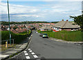
Marlborough Road, Skelton
Looking north.
Image: © Christine Johnstone
Taken: 3 Apr 2015
0.08 miles
9
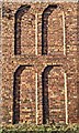
Gable wall of Home Farm
This is the end wall of a row of cottages attached to the Home Farm of the Wharton Estate of Skelton Castle. The Home Farm was the estate's show farm where the latest agricultural methods could be displayed to visitors. As a result, the building had some architectural extravagance.
Image: © Mick Garratt
Taken: 20 Nov 2019
0.08 miles
10
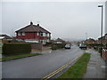
Grampian Road, Skelton
Down the hill from High Street to suburbia.
Image: © Humphrey Bolton
Taken: 2 Aug 2020
0.08 miles