IMAGES TAKEN NEAR TO
Saltburn Lane, SALTBURN-BY-THE-SEA, TS12 2JU
Introduction
This page details the photographs taken nearby to Saltburn Lane, TS12 2JU by members of the Geograph project.
The Geograph project started in 2005 with the aim of publishing, organising and preserving representative images for every square kilometre of Great Britain, Ireland and the Isle of Man.

There are currently over 7.5m images from over14,400 individuals and you can help contribute to the project by visiting https://www.geograph.org.uk
Image Map
Images are licensed for reuse under creativecommons.org/licenses/by-sa/2.0
Notes
- Clicking on the map will re-center to the selected point.
- The higher the marker number, the further away the image location is from the centre of the postcode.
Image Listing (9 Images Found)
Images are licensed for reuse under creativecommons.org/licenses/by-sa/2.0
Image
Details
Distance
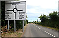
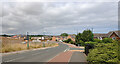
7
Roundabout on Saltburn Lane
This photograph shows a view of a roundabout at the intersection of Saltburn Lane with the A174 road. The picture was taken from the western limb of the A174 road looking in an easterly direction towards Brotton - parts of which can just be seen in the distance. The road on the right leads to Skelton.
Image: © Philip Barker
Taken: 25 Jun 2010
0.19 miles
8
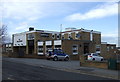
The Hollybush pub, New Skelton
On Station Road.
Image: © JThomas
Taken: 8 Feb 2014
0.24 miles