IMAGES TAKEN NEAR TO
Skelton-in-Cleveland, SALTBURN-BY-THE-SEA, TS12 2BB
Introduction
This page details the photographs taken nearby to TS12 2BB by members of the Geograph project.
The Geograph project started in 2005 with the aim of publishing, organising and preserving representative images for every square kilometre of Great Britain, Ireland and the Isle of Man.

There are currently over 7.5m images from over14,400 individuals and you can help contribute to the project by visiting https://www.geograph.org.uk
Image Map (Loading...)


Getting Data...Please wait
Leaflet Map data © OpenStreetMap
Images are licensed for reuse under creativecommons.org/licenses/by-sa/2.0
Notes
- Clicking on the map will re-center to the selected point.
- The higher the marker number, the further away the image location is from the centre of the postcode.
Image Listing (7 Images Found)
Images are licensed for reuse under creativecommons.org/licenses/by-sa/2.0
Image
Details
Distance
1
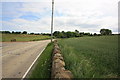
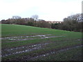
Stanghow Road near the dismantled railway
This photograph shows a view of a section of Stanghow Road as it passes the entrance to Wet Furrows Farm. The railway bridge is hidden by the trees but a section of the embankment can just be seen to the left of the building that is visible in the right-hand side of the image. The railway bridge can be seen here: Image The picture was taken looking in a south-south-easterly direction towards Claphow.
Image: © Philip Barker
Taken: 25 Jun 2010
0.18 miles
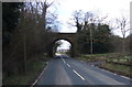
4
Railway Bridge, Stanghow Road
The bridge carried a mineral line, now dismantled, to the Skelton ironstone mine nearby.
Image: © Mick Garratt
Taken: 7 Sep 2006
0.23 miles
6
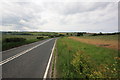
Stanghow Road
This photograph shows a view of the section of Stanghow Road that passes through the north-eastern corner of the grid-square. Skelton Green can be seen on the horizon in the left-hand side of the image. Trout Hall and parts of Skelton are also visible in the right-hand-side of the scene. The picture was taken looking in a north-north-westerly direction towards Skelton.
Image: © Philip Barker
Taken: 25 Jun 2010
0.24 miles
