IMAGES TAKEN NEAR TO
Windy Hill Lane, REDCAR, TS11 7DZ
Introduction
This page details the photographs taken nearby to Windy Hill Lane, TS11 7DZ by members of the Geograph project.
The Geograph project started in 2005 with the aim of publishing, organising and preserving representative images for every square kilometre of Great Britain, Ireland and the Isle of Man.

There are currently over 7.5m images from over14,400 individuals and you can help contribute to the project by visiting https://www.geograph.org.uk
Image Map
Images are licensed for reuse under creativecommons.org/licenses/by-sa/2.0
Notes
- Clicking on the map will re-center to the selected point.
- The higher the marker number, the further away the image location is from the centre of the postcode.
Image Listing (5 Images Found)
Images are licensed for reuse under creativecommons.org/licenses/by-sa/2.0
Image
Details
Distance
1
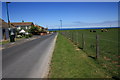
Howard Drive, Marske-by-the-Sea
This photograph shows a view of Howard Drive and the fenced-off grassland that lies to the east of it. The junction with Fenner Close can be seen on the left-hand side of the road and further down the junction with Raleigh Close is just visible. Viewers with good eye-sight might see the three ships on the horizon. The picture was taken looking in a north-north-easterly direction towards Windy Hill Lane - which is just visible near the public footpath sign.
Image: © Philip Barker
Taken: 17 Jun 2010
0.07 miles
3
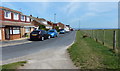
Houses along Howard Drive
On the eastern edge of Marske-by-the-Sea.
Image: © Mat Fascione
Taken: 9 Aug 2018
0.20 miles
4
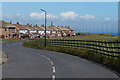
Church Howle Crescent in Marske-by-the-Sea
Image: © Mat Fascione
Taken: 9 Aug 2018
0.21 miles
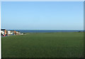
5
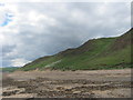
Sand dunes and rear of beach at Marske-By-The- Sea
Image: © Peter Robinson
Taken: 16 Jun 2013
0.24 miles