IMAGES TAKEN NEAR TO
Blenheim Avenue, REDCAR, TS11 6BB
Introduction
This page details the photographs taken nearby to Blenheim Avenue, TS11 6BB by members of the Geograph project.
The Geograph project started in 2005 with the aim of publishing, organising and preserving representative images for every square kilometre of Great Britain, Ireland and the Isle of Man.

There are currently over 7.5m images from over14,400 individuals and you can help contribute to the project by visiting https://www.geograph.org.uk
Image Map
Images are licensed for reuse under creativecommons.org/licenses/by-sa/2.0
Notes
- Clicking on the map will re-center to the selected point.
- The higher the marker number, the further away the image location is from the centre of the postcode.
Image Listing (18 Images Found)
Images are licensed for reuse under creativecommons.org/licenses/by-sa/2.0
Image
Details
Distance
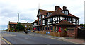
1
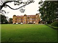
Marske Hall
Now a Leonard Cheshire Home.
Image: © Bill Henderson
Taken: 16 Aug 2019
0.15 miles
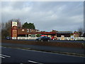
2
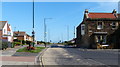
A1085 Coast Road in Marske-by-the-Sea
At the junction with the High Street.
Image: © Mat Fascione
Taken: 9 Aug 2018
0.18 miles
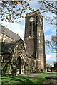
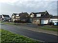
9
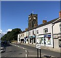
Redcar Road, Marske-by-the-Sea
The tower of St Mark's Church behind the shops
Image: © Eirian Evans
Taken: 15 Sep 2021
0.20 miles
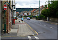
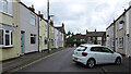
10
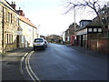
High Street, Marske-by-the-Sea
Looking east.
Image: © JThomas
Taken: 25 Jan 2014
0.21 miles