IMAGES TAKEN NEAR TO
Wheeldale Avenue, REDCAR, TS10 5HF
Introduction
This page details the photographs taken nearby to Wheeldale Avenue, TS10 5HF by members of the Geograph project.
The Geograph project started in 2005 with the aim of publishing, organising and preserving representative images for every square kilometre of Great Britain, Ireland and the Isle of Man.

There are currently over 7.5m images from over14,400 individuals and you can help contribute to the project by visiting https://www.geograph.org.uk
Image Map
Images are licensed for reuse under creativecommons.org/licenses/by-sa/2.0
Notes
- Clicking on the map will re-center to the selected point.
- The higher the marker number, the further away the image location is from the centre of the postcode.
Image Listing (20 Images Found)
Images are licensed for reuse under creativecommons.org/licenses/by-sa/2.0
Image
Details
Distance
1
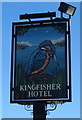
Sign for the Kingfisher Hotel, Dormanstown, Redcar
Image: © JThomas
Taken: 23 Feb 2019
0.05 miles
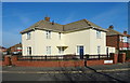
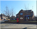
3
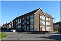
Flats on Farndale Square, Redcar
Showing position of Postbox No. TS10 255.
See Image] for postbox.
Image: © JThomas
Taken: 23 Feb 2019
0.06 miles
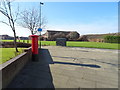
4
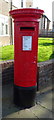
George VI postbox on Farndale Square, Redcar
Postbox No. TS10 255.
See Image] for context.
Image: © JThomas
Taken: 23 Feb 2019
0.06 miles
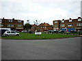
5
The Kingfisher Hotel, Dormanstown, Redcar
On Farndale Square.
Image: © JThomas
Taken: 23 Feb 2019
0.06 miles
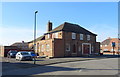
9
House on Eskdale Road, Dormanstown, Redcar
Showing position of Postbox No. TS10 221.
See Image] for postbox.
Image: © JThomas
Taken: 23 Feb 2019
0.16 miles
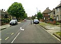
10
Eskdale Road, Dormanstown, Redcar
Showing position of Postbox No. TS10 221.
See Image] for postbox.
Image: © JThomas
Taken: 23 Feb 2019
0.16 miles