IMAGES TAKEN NEAR TO
Tod Point Road, REDCAR, TS10 5AU
Introduction
This page details the photographs taken nearby to Tod Point Road, TS10 5AU by members of the Geograph project.
The Geograph project started in 2005 with the aim of publishing, organising and preserving representative images for every square kilometre of Great Britain, Ireland and the Isle of Man.

There are currently over 7.5m images from over14,400 individuals and you can help contribute to the project by visiting https://www.geograph.org.uk
Image Map (Loading...)


Getting Data...Please wait
Leaflet Map data © OpenStreetMap
Images are licensed for reuse under creativecommons.org/licenses/by-sa/2.0
Notes
- Clicking on the map will re-center to the selected point.
- The higher the marker number, the further away the image location is from the centre of the postcode.
Image Listing (33 Images Found)
Images are licensed for reuse under creativecommons.org/licenses/by-sa/2.0
Image
Details
Distance
1
Warrenby's Rest
Cafe on Tod Point Road, Warrenby.
Image: © JThomas
Taken: 23 Feb 2019
0.04 miles
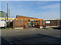
2
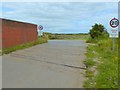
Tod Point Road, Warrenby
Commercial premises at the end of a residential road on the outskirts of Redcar.
Image: © Oliver Dixon
Taken: 26 Jun 2017
0.05 miles
3
Teesdale Way in Warrenby
Road adopted by the long distance footpath in Warrenby.
Image: © Chris Heaton
Taken: 3 Nov 2010
0.05 miles
4
Former school at Warrenby
Another survivor at the ghost town of Warrenby.
This former school is now an industrial unit
Image: © Stephen McCulloch
Taken: 24 Apr 2007
0.09 miles
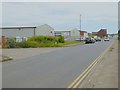
5
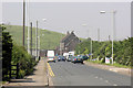
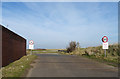
Tod Point Road (west end)
The western end of Tod Point Road, once the centre of a thriving village at Warrenby. A farm house survives at the end of the road, with the steelworks beyond.
Image: © George Robinson
Taken: 11 Jun 2007
0.10 miles
6
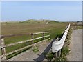
Steps to lane for Coatham Marsh Nature Reserve viewpoint
Image: © Peter Robinson
Taken: 30 Oct 2011
0.12 miles
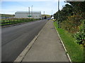
7
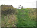
England Coast Path
The England Coast Path follows a bridleway over the Cleveland Golf Club on its way to the beach at Redcar. The path is not well signed from the other direction at the far side of the golf course.
Image: © Oliver Dixon
Taken: 18 Apr 2019
0.14 miles
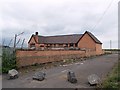
8
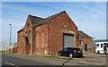
Former St Marys Church, Warrenby
Built in 1953 but was only open until 1978.
Now in commercial use.
Warrenby was once a thriving community, but is now only commercial.
Image: © JThomas
Taken: 23 Feb 2019
0.14 miles
9
Old railway crossing
The rest of the track has been lifted, but still remains at this crossing of the road into the back of the Teesside Steelworks.
Image: © Oliver Dixon
Taken: 26 Jun 2017
0.14 miles
10
Former level crossing on the road towards South Gare
The track has long since been discontinued.
Image: © JThomas
Taken: 23 Feb 2019
0.14 miles