IMAGES TAKEN NEAR TO
Wilton, REDCAR, TS10 4RG
Introduction
This page details the photographs taken nearby to TS10 4RG by members of the Geograph project.
The Geograph project started in 2005 with the aim of publishing, organising and preserving representative images for every square kilometre of Great Britain, Ireland and the Isle of Man.

There are currently over 7.5m images from over14,400 individuals and you can help contribute to the project by visiting https://www.geograph.org.uk
Image Map
Images are licensed for reuse under creativecommons.org/licenses/by-sa/2.0
Notes
- Clicking on the map will re-center to the selected point.
- The higher the marker number, the further away the image location is from the centre of the postcode.
Image Listing (2 Images Found)
Images are licensed for reuse under creativecommons.org/licenses/by-sa/2.0
Image
Details
Distance
1
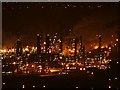
Huntsman Olefins Plant
A blatant view bag taken from the top of Eston Nab. Wilton International Site was formerly owned by ICI but is now in the hands of several operating companies and the facilities management company. It is entirely privately owned and since changing jobs I no longer have a pass to get onto the site although even if I did taking and publishing photos would not be popular if caught. This particular square is dominated by the Olefins plant operated by Huntsman Petrochemicals.
Update Nov 2010: Huntsman's operations on Teesside have now been taken over by the Saudi company Sabic Petrochemicals.
Image: © Mick Garratt
Taken: 24 Jan 2006
0.14 miles
2
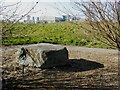
Erratic Boulder, Wilton
This 3.8 ton piece of calcareous limestone (containing shells) was transported by glaciers and deposited on flood plain of the Tees between 70,000 and 13,000 years ago, the Wilton petrochemical works being built around it.
Image: © Mick Garratt
Taken: 14 Mar 2007
0.23 miles