IMAGES TAKEN NEAR TO
Greystoke Walk, REDCAR, TS10 4PN
Introduction
This page details the photographs taken nearby to Greystoke Walk, TS10 4PN by members of the Geograph project.
The Geograph project started in 2005 with the aim of publishing, organising and preserving representative images for every square kilometre of Great Britain, Ireland and the Isle of Man.

There are currently over 7.5m images from over14,400 individuals and you can help contribute to the project by visiting https://www.geograph.org.uk
Image Map
Images are licensed for reuse under creativecommons.org/licenses/by-sa/2.0
Notes
- Clicking on the map will re-center to the selected point.
- The higher the marker number, the further away the image location is from the centre of the postcode.
Image Listing (6 Images Found)
Images are licensed for reuse under creativecommons.org/licenses/by-sa/2.0
Image
Details
Distance
2
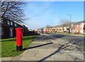
West Dyke Road, Redcar
Showing position of Postbox No. TS10 296.
See Image] for postbox.
Image: © JThomas
Taken: 23 Feb 2019
0.16 miles
3
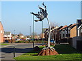
Steel tree sculpture on West Dyke Road, Redcar
One of a pair - see Image]
Image: © JThomas
Taken: 23 Feb 2019
0.16 miles
4
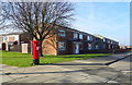
Houses on West Dyke Road, Redcar
Showing position of Postbox No. TS10 296.
See Image] for postbox.
Image: © JThomas
Taken: 23 Feb 2019
0.17 miles
5
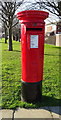
Elizabeth II postbox on West Dyke Road, Redcar
Image: © JThomas
Taken: 23 Feb 2019
0.17 miles
6
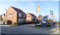
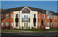
Scholars Park
New housing in Redcar off Redcar Lane.
Image: © JThomas
Taken: 23 Feb 2019
0.25 miles