IMAGES TAKEN NEAR TO
TS10 4EQ
Introduction
This page details the photographs taken nearby to TS10 4EQ by members of the Geograph project.
The Geograph project started in 2005 with the aim of publishing, organising and preserving representative images for every square kilometre of Great Britain, Ireland and the Isle of Man.

There are currently over 7.5m images from over14,400 individuals and you can help contribute to the project by visiting https://www.geograph.org.uk
Image Map
Images are licensed for reuse under creativecommons.org/licenses/by-sa/2.0
Notes
- Clicking on the map will re-center to the selected point.
- The higher the marker number, the further away the image location is from the centre of the postcode.
Image Listing (13 Images Found)
Images are licensed for reuse under creativecommons.org/licenses/by-sa/2.0
Image
Details
Distance
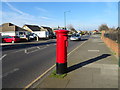
1
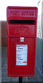
Close up, Elizabeth II postbox on Ayton Drive, Redcar
Image: © JThomas
Taken: 23 Feb 2019
0.04 miles
2
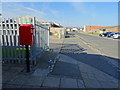
Ayton Drive, Redcar
Showing position of Postbox No. TS10 51.
See Image] for postbox.
Image: © JThomas
Taken: 23 Feb 2019
0.04 miles
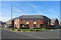
3
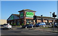
Asda Supermarket, Redcar
On Roseberry Road.
Image: © JThomas
Taken: 23 Feb 2019
0.05 miles
4
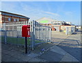
Elizabeth II postbox on Ayton Drive, Redcar
Image: © JThomas
Taken: 23 Feb 2019
0.05 miles
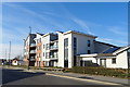
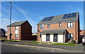
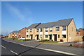
8

Oxendale Road, Redcar
Recently developed area - looking east.
Image: © JThomas
Taken: 23 Feb 2019
0.08 miles
10
West Dyke Road, Redcar
Showing position of Postbox No. TS10 229.
See Image] for postbox.
Image: © JThomas
Taken: 23 Feb 2019
0.23 miles