IMAGES TAKEN NEAR TO
Stanley Grove, REDCAR, TS10 3LF
Introduction
This page details the photographs taken nearby to Stanley Grove, TS10 3LF by members of the Geograph project.
The Geograph project started in 2005 with the aim of publishing, organising and preserving representative images for every square kilometre of Great Britain, Ireland and the Isle of Man.

There are currently over 7.5m images from over14,400 individuals and you can help contribute to the project by visiting https://www.geograph.org.uk
Image Map
Images are licensed for reuse under creativecommons.org/licenses/by-sa/2.0
Notes
- Clicking on the map will re-center to the selected point.
- The higher the marker number, the further away the image location is from the centre of the postcode.
Image Listing (165 Images Found)
Images are licensed for reuse under creativecommons.org/licenses/by-sa/2.0
Image
Details
Distance
2
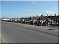
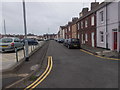
Fisherman's Square, Redcar
Quite a surprise to find this a block away from the coast. The tractor on the right is a veteran, judging by its registration plate.
Image: © Humphrey Bolton
Taken: 27 Apr 2011
0.03 miles
3
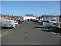
Fisherman's Square boat park, Redcar
The fishermen seem to be having a day off.
Image: © Humphrey Bolton
Taken: 27 Apr 2011
0.04 miles
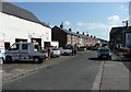
7
South Terrace - Fisherman's Square
Image: © Betty Longbottom
Taken: 25 Jul 2017
0.05 miles
10
East Cleveland Baptist Church - Stanley Grove
Image: © Betty Longbottom
Taken: 25 Jul 2017
0.07 miles