IMAGES TAKEN NEAR TO
Embleton Court, REDCAR, TS10 2RF
Introduction
This page details the photographs taken nearby to Embleton Court, TS10 2RF by members of the Geograph project.
The Geograph project started in 2005 with the aim of publishing, organising and preserving representative images for every square kilometre of Great Britain, Ireland and the Isle of Man.

There are currently over 7.5m images from over14,400 individuals and you can help contribute to the project by visiting https://www.geograph.org.uk
Image Map
Images are licensed for reuse under creativecommons.org/licenses/by-sa/2.0
Notes
- Clicking on the map will re-center to the selected point.
- The higher the marker number, the further away the image location is from the centre of the postcode.
Image Listing (17 Images Found)
Images are licensed for reuse under creativecommons.org/licenses/by-sa/2.0
Image
Details
Distance
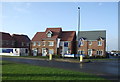
2
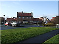
The Turners Mill public house, Redcar
An Ember Inn on Greenstones Road.
Image: © JThomas
Taken: 23 Feb 2019
0.05 miles
3

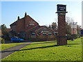
Sign for the Turners Mill public house, Redcar
Image: © JThomas
Taken: 23 Feb 2019
0.06 miles
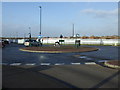
6
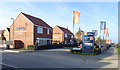
Scholars Park
New housing in Redcar off Redcar Lane.
Image: © JThomas
Taken: 23 Feb 2019
0.13 miles

9
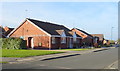
Bungalows on The Hampstead, Redcar
Off Greenstones Road.
Image: © JThomas
Taken: 23 Feb 2019
0.19 miles