IMAGES TAKEN NEAR TO
Peirson Street, REDCAR, TS10 1SW
Introduction
This page details the photographs taken nearby to Peirson Street, TS10 1SW by members of the Geograph project.
The Geograph project started in 2005 with the aim of publishing, organising and preserving representative images for every square kilometre of Great Britain, Ireland and the Isle of Man.

There are currently over 7.5m images from over14,400 individuals and you can help contribute to the project by visiting https://www.geograph.org.uk
Image Map (Loading...)


Getting Data...Please wait
Leaflet Map data © OpenStreetMap
Images are licensed for reuse under creativecommons.org/licenses/by-sa/2.0
Notes
- Clicking on the map will re-center to the selected point.
- The higher the marker number, the further away the image location is from the centre of the postcode.
Image Listing (232 Images Found)
Images are licensed for reuse under creativecommons.org/licenses/by-sa/2.0
Image
Details
Distance
2
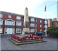
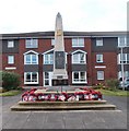
Garden of Remembrance, Redcar
On Coatham Road opposite the War Memorial.
Image: © JThomas
Taken: 23 Feb 2019
0.03 miles
9
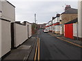
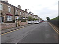
Coatham Road, Redcar
Seen at the junction with Lobster Road; the Coatham Road Social Club, seemingly no more than converted houses, is on the corner.
Image: © Stephen McKay
Taken: 18 Jul 2017
0.06 miles