IMAGES TAKEN NEAR TO
Hornsea Grove, REDCAR, TS10 1QU
Introduction
This page details the photographs taken nearby to Hornsea Grove, TS10 1QU by members of the Geograph project.
The Geograph project started in 2005 with the aim of publishing, organising and preserving representative images for every square kilometre of Great Britain, Ireland and the Isle of Man.

There are currently over 7.5m images from over14,400 individuals and you can help contribute to the project by visiting https://www.geograph.org.uk
Image Map
Images are licensed for reuse under creativecommons.org/licenses/by-sa/2.0
Notes
- Clicking on the map will re-center to the selected point.
- The higher the marker number, the further away the image location is from the centre of the postcode.
Image Listing (32 Images Found)
Images are licensed for reuse under creativecommons.org/licenses/by-sa/2.0
Image
Details
Distance
1
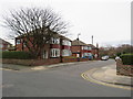
Hornsea Grove, Redcar
Hornsea Grove is a short residential cul-de-sac in Redcar.
Image: © Malc McDonald
Taken: 2 Mar 2019
0.01 miles
2
Kirkleatham Lane bridge over the Middlesbrough to Saltburn Railway
Image: © Peter Robinson
Taken: 9 Jun 2013
0.07 miles
4
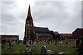
Christ Church
The parish church of Coatham and Dormanstown
Image: © George Ford
Taken: 6 Aug 2005
0.09 miles
5
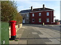
Houses on Bridge Road, Redcar
Showing position of Postbox No. TS10 133.
See Image] for postbox.
Image: © JThomas
Taken: 23 Feb 2019
0.10 miles
6
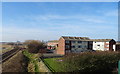
Flats beside the railway
View from the bridge on Kirkleatham Lane.
Image: © JThomas
Taken: 23 Feb 2019
0.10 miles
7
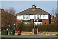
House on York Road, Redcar
Showing position of Postbox No. TS10 133.
See Image] for postbox.
Image: © JThomas
Taken: 23 Feb 2019
0.11 miles
8
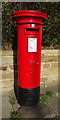
George V postbox on York Road, Redcar
Image: © JThomas
Taken: 23 Feb 2019
0.11 miles
9
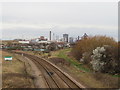
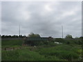
Railway at Redcar
A double-track railway at Redcar, looking towards the steelworks.
The railway previously veered to the right. Its former course is clearly visible. The railway was realigned in 1978 to enable the steelworks to expand over the original route.
Image: © Malc McDonald
Taken: 2 Mar 2019
0.11 miles
10
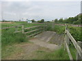
Old cart bridge over The Fleet in Coatham Marsh Nature Reserve
Now restricted to pedestrian and cycling use
Image: © Peter Robinson
Taken: 9 Jun 2013
0.11 miles