IMAGES TAKEN NEAR TO
Higher Fraddon, ST. COLUMB, TR9 6TG
Introduction
This page details the photographs taken nearby to TR9 6TG by members of the Geograph project.
The Geograph project started in 2005 with the aim of publishing, organising and preserving representative images for every square kilometre of Great Britain, Ireland and the Isle of Man.

There are currently over 7.5m images from over14,400 individuals and you can help contribute to the project by visiting https://www.geograph.org.uk
Image Map
Images are licensed for reuse under creativecommons.org/licenses/by-sa/2.0
Notes
- Clicking on the map will re-center to the selected point.
- The higher the marker number, the further away the image location is from the centre of the postcode.
Image Listing (11 Images Found)
Images are licensed for reuse under creativecommons.org/licenses/by-sa/2.0
Image
Details
Distance
1
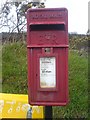
Pedna Carne Post box
Just outside mobile-home site
Image: © Phil
Taken: 27 Mar 2009
0.07 miles
2
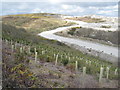
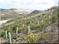
Haul road at Wheal Remfry china clay pit
In the foreground the former spoil heap has been planted to stabilise and re-vegetate the otherwise barren surface.
Image: © Rod Allday
Taken: 4 Apr 2009
0.15 miles
3
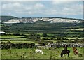
Wheel Remfrey tip from St Dennis
Looking across the Cornish China clay mining landscape to the spoil heap of the Wheal Remfrey works. Taken from beside Image]
Image: © Rob Farrow
Taken: 2 Sep 2023
0.20 miles
7
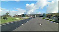
A30 crossed by footbridge from Pedna-Carne Caravan Park
Image: © Stuart Logan
Taken: 14 Oct 2012
0.21 miles
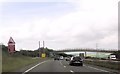
8
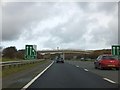
Footbridge over A30 at Fraddon
The bridge gives a convenient short cut from Pedna-Carne Caravan Park on the right to Fraddon on the left. There was a minor road or track along the route before the dual carriageway was built, but the bridge is not built for cars. The signs show the end of the crawler lane
Image: © David Smith
Taken: 1 Feb 2013
0.22 miles
9
Land reclamation at Wheal Remfry china clay pit
The slope of the spoil heap in the foreground has been planted to stabilise its surface and revegetate this otherwise barren landscape. In the distance can be seen a conical spoil heap in the adjacent square SW9256.
Image: © Rod Allday
Taken: 4 Apr 2009
0.23 miles
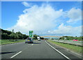
10

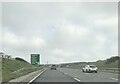
Cornwall : The A30
Heading along the A30 with a turn off to Wadebridge, Newquay and St Dennis approaching.
Image: © Lewis Clarke
Taken: 17 Jul 2015
0.23 miles