IMAGES TAKEN NEAR TO
Quoit, ST. COLUMB, TR9 6HY
Introduction
This page details the photographs taken nearby to TR9 6HY by members of the Geograph project.
The Geograph project started in 2005 with the aim of publishing, organising and preserving representative images for every square kilometre of Great Britain, Ireland and the Isle of Man.

There are currently over 7.5m images from over14,400 individuals and you can help contribute to the project by visiting https://www.geograph.org.uk
Image Map
Images are licensed for reuse under creativecommons.org/licenses/by-sa/2.0
Notes
- Clicking on the map will re-center to the selected point.
- The higher the marker number, the further away the image location is from the centre of the postcode.
Image Listing (3 Images Found)
Images are licensed for reuse under creativecommons.org/licenses/by-sa/2.0
Image
Details
Distance
1
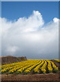
Field of daffodils near Walhalla
As these flowers are in full bloom it is likely that they are being grown for bulbs - if they were for the cut flower market they would be picked whilst in bud.
Image: © Rod Allday
Taken: 2 Apr 2010
0.06 miles
3
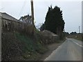
Farm buildings
Southleigh Manor, at Walhalla, is not marked on either 1:50000 (revised 2001) or the 1:25000 (revised 2003). The buildings are certainly older than that, but the function may not be.
Image: © Neville Goodman
Taken: 9 Oct 2007
0.09 miles