IMAGES TAKEN NEAR TO
Quoit, ST. COLUMB, TR9 6HX
Introduction
This page details the photographs taken nearby to TR9 6HX by members of the Geograph project.
The Geograph project started in 2005 with the aim of publishing, organising and preserving representative images for every square kilometre of Great Britain, Ireland and the Isle of Man.

There are currently over 7.5m images from over14,400 individuals and you can help contribute to the project by visiting https://www.geograph.org.uk
Image Map
Images are licensed for reuse under creativecommons.org/licenses/by-sa/2.0
Notes
- Clicking on the map will re-center to the selected point.
- The higher the marker number, the further away the image location is from the centre of the postcode.
Image Listing (5 Images Found)
Images are licensed for reuse under creativecommons.org/licenses/by-sa/2.0
Image
Details
Distance
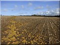
1
Valley by Quoit Farm
The building on the left is part of a holiday amusement attraction.
Image: © Tony Atkin
Taken: 19 Aug 2006
0.06 miles
2
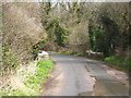
Bridge over a stream near Quoit Farm
Bears a datestone of 1861 on its parapet.
Image: © Rod Allday
Taken: 2 Apr 2010
0.09 miles
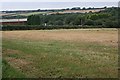
3
Entrance to Springfields Fun Park and Pony Centre
A popular amusement park within easy reach of Newquay.
Image: © Rod Allday
Taken: 2 Apr 2010
0.17 miles
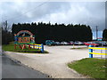
4
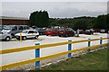
Holiday Fun Park
A vivid yellow and blue fence at the roadside announces this children's fun park attraction which is quite popular judging by the number of cars but then it is a cloudy day in August, just the sort of day when holidaymakers look for an alternative to the beach.
Image: © Tony Atkin
Taken: 19 Aug 2006
0.21 miles