IMAGES TAKEN NEAR TO
Penmellyn Gardens, Lower East Street, ST. COLUMB, TR9 6FN
Introduction
This page details the photographs taken nearby to Penmellyn Gardens, Lower East Street, TR9 6FN by members of the Geograph project.
The Geograph project started in 2005 with the aim of publishing, organising and preserving representative images for every square kilometre of Great Britain, Ireland and the Isle of Man.

There are currently over 7.5m images from over14,400 individuals and you can help contribute to the project by visiting https://www.geograph.org.uk
Image Map
Images are licensed for reuse under creativecommons.org/licenses/by-sa/2.0
Notes
- Clicking on the map will re-center to the selected point.
- The higher the marker number, the further away the image location is from the centre of the postcode.
Image Listing (31 Images Found)
Images are licensed for reuse under creativecommons.org/licenses/by-sa/2.0
Image
Details
Distance
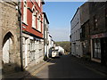
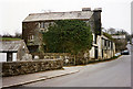
2
St Columb Major
Mechanics Institute in St Columb - presumably the old school.
Image: © Jill Floyd
Taken: 8 Sep 2008
0.08 miles
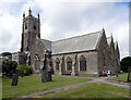
5
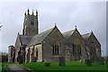
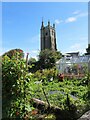
St Columb Major Church
A large church which dates from the 12th Century it is dedicated to Saint Columba. The church looks isolated here but is in fact adjacent to the cramped buildings of the town centre.
Image: © Tony Atkin
Taken: 22 Nov 2009
0.10 miles
7
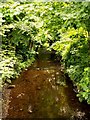
The River Menalhyl
From the bridge by the Toll House in St. Columb the River Menalhyl flows on towards Mawgan Porth and the Atlantic Ocean.
Image: © Barry
Taken: 23 Jun 2005
0.11 miles
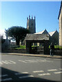
8
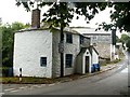
The Toll House
On the road leaving St. Columb heading for St. Mawgan, at the bottom of Bridge Hill by the bridge over the River Menalhyl, is this former toll keepers cottage.
Image: © Barry
Taken: 29 Sep 2005
0.11 miles
9
St Columb Major: Bridge Mill
Thought also to have been known as Manor Mills or Town Mills at other times, but it was known as Bridge Mill in 1856. On a road north out of St Columb. Once powered by a leat from the river Menalhyl. Only a short distance upstream is a second watermill – Thirlby Mill – now a private residence
Image: © Martin Bodman
Taken: Unknown
0.11 miles
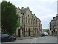
10
Buildings at the Centre of St Columb
The formal white-painted front of the Conservative Club Building (to let) contrasts with the brown and grey stone at the rear of the Library Building.
Image: © Tony Atkin
Taken: 22 Nov 2009
0.11 miles