IMAGES TAKEN NEAR TO
Tregonetha, ST. COLUMB, TR9 6EN
Introduction
This page details the photographs taken nearby to TR9 6EN by members of the Geograph project.
The Geograph project started in 2005 with the aim of publishing, organising and preserving representative images for every square kilometre of Great Britain, Ireland and the Isle of Man.

There are currently over 7.5m images from over14,400 individuals and you can help contribute to the project by visiting https://www.geograph.org.uk
Image Map
Images are licensed for reuse under creativecommons.org/licenses/by-sa/2.0
Notes
- Clicking on the map will re-center to the selected point.
- The higher the marker number, the further away the image location is from the centre of the postcode.
Image Listing (6 Images Found)
Images are licensed for reuse under creativecommons.org/licenses/by-sa/2.0
Image
Details
Distance
1
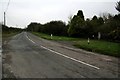
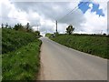
Country road
There is a house on the B3274 between the collection of buildings at Penhellick and the hamlet of Tregonetha. It hides behind a fine gate and row of trees.
Image: © Neville Goodman
Taken: 14 Oct 2007
0.08 miles
2
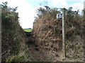
Field near Tregonetha
A field boundary climbs away from the B3274 at Richmond, with an ivy-covered telegraph pole on the left. Taken beside the stretch of road shown in Image
Image: © Derek Harper
Taken: 14 Jul 2010
0.12 miles
3
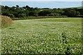
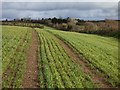
Farmland, St Wenn
Some clover-rich grassland crossed by the footpath north of Tregonetha.
Image: © Andrew Smith
Taken: 11 Jul 2022
0.15 miles
5
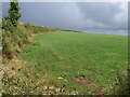
Approaching the B3274 near Pengelly Farm
Image: © David Gearing
Taken: 13 May 2014
0.23 miles