IMAGES TAKEN NEAR TO
ST. COLUMB, TR9 6DZ
Introduction
This page details the photographs taken nearby to TR9 6DZ by members of the Geograph project.
The Geograph project started in 2005 with the aim of publishing, organising and preserving representative images for every square kilometre of Great Britain, Ireland and the Isle of Man.

There are currently over 7.5m images from over14,400 individuals and you can help contribute to the project by visiting https://www.geograph.org.uk
Image Map
Images are licensed for reuse under creativecommons.org/licenses/by-sa/2.0
Notes
- Clicking on the map will re-center to the selected point.
- The higher the marker number, the further away the image location is from the centre of the postcode.
Image Listing (4 Images Found)
Images are licensed for reuse under creativecommons.org/licenses/by-sa/2.0
Image
Details
Distance
1
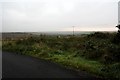
Cornish countryside
The view SW over the Cornish countryside on a dull day in October, from a driveway near Penhellick.
Image: © Neville Goodman
Taken: 14 Oct 2007
0.08 miles
2
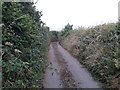
An infrequently used lane, judging by the grass in the middle
Image: © Rob Purvis
Taken: 6 Aug 2014
0.14 miles
3
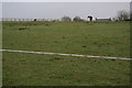
House and horse on a hill
The lane to Borlasevath is so narrow that it isn't possible to stop a car and open a door unless at a gate into a field. A house at Penhellick is visible over the brow of the slight hill, beyond the horse, which wandered over to see what was going on.
Image: © Neville Goodman
Taken: 14 Oct 2007
0.16 miles
4
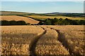
Farmland, St Columb Major
A crop of barley is about ready for harvest to the west of Penhellick.
Image: © Andrew Smith
Taken: 11 Jul 2022
0.19 miles