IMAGES TAKEN NEAR TO
Carloggas Way, ST. COLUMB, TR9 6BH
Introduction
This page details the photographs taken nearby to Carloggas Way, TR9 6BH by members of the Geograph project.
The Geograph project started in 2005 with the aim of publishing, organising and preserving representative images for every square kilometre of Great Britain, Ireland and the Isle of Man.

There are currently over 7.5m images from over14,400 individuals and you can help contribute to the project by visiting https://www.geograph.org.uk
Image Map
Images are licensed for reuse under creativecommons.org/licenses/by-sa/2.0
Notes
- Clicking on the map will re-center to the selected point.
- The higher the marker number, the further away the image location is from the centre of the postcode.
Image Listing (7 Images Found)
Images are licensed for reuse under creativecommons.org/licenses/by-sa/2.0
Image
Details
Distance

2
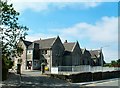
St. Columb Major CP School
St. Columb Major CP School, opposite the new Fire Station on the Newquay Road.
Image: © Barry
Taken: 3 Aug 2006
0.10 miles
3
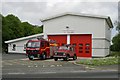
St Columb Fire Station
St Columb fire station, Newquay Road, St Columb, Cornwall was built to replace the previous cramped fire station in Fair Street. Image
Image: © Kevin Hale
Taken: 21 May 2006
0.19 miles
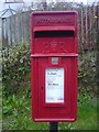
5
St Columb Industrial Estate - Post box
TR9 106 - Modern Pillar box
Image: © Phil
Taken: 27 Mar 2009
0.24 miles
6
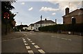
St Columb Major : Newquay Road
Newquay Road in Columb Major taken from the junction at Trekenning Road.
Image: © Lewis Clarke
Taken: 1 Jul 2011
0.24 miles
