IMAGES TAKEN NEAR TO
Penhaven Close, NEWQUAY, TR8 5SJ
Introduction
This page details the photographs taken nearby to Penhaven Close, TR8 5SJ by members of the Geograph project.
The Geograph project started in 2005 with the aim of publishing, organising and preserving representative images for every square kilometre of Great Britain, Ireland and the Isle of Man.

There are currently over 7.5m images from over14,400 individuals and you can help contribute to the project by visiting https://www.geograph.org.uk
Image Map
Images are licensed for reuse under creativecommons.org/licenses/by-sa/2.0
Notes
- Clicking on the map will re-center to the selected point.
- The higher the marker number, the further away the image location is from the centre of the postcode.
Image Listing (39 Images Found)
Images are licensed for reuse under creativecommons.org/licenses/by-sa/2.0
Image
Details
Distance
2
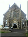
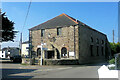
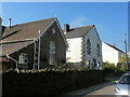
Methodist Church, St Newlyn East
The use of this building as a Methodist Church appears to be quite recent. A much larger building which has now been converted into private residences may have been the original church.
Image: © Tony Atkin
Taken: 10 Jun 2006
0.12 miles
3
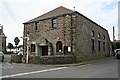
The Old Chapel, St Newlyn East
The Old Chapel in St Newlyn East appears to have been converted into residential accommodation.
Image: © Philip Halling
Taken: 17 Mar 2016
0.13 miles
5
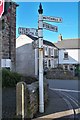
Direction Sign - Signpost by Station Road, St Newlyn East
Pyramid spear finial - one plastic arm; Cornwall CC iron spear by the UC road, in parish of St Newlyn East (Carrick District), Newlyn East Methodist Church, junction with Station Road, at back of footpath, against boundary wall.
Grade II listed.
List Entry Number: 1141455 https://historicengland.org.uk/listing/the-list/list-entry/1141455
Surveyed
Milestone Society National ID: CW_SW8256
Image: © Milestone Society
Taken: Unknown
0.15 miles
6
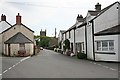
St Newlyn East
In case you were wondering about the title, the name of this village is 'St Newlyn East'. This photo looks east along a street called 'The Cross' at the centre of the village towards the church.
Image: © Tony Atkin
Taken: 10 Jun 2006
0.16 miles
7
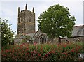
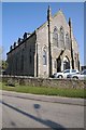
St Newlyn East Church
This church has been around since 1259 and like many churches underwent major renewal in the 19th century. It is dedicated to St Newelina.
Image: © Tony Atkin
Taken: 10 Jun 2006
0.16 miles
8
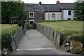
Churchtown, St Newlyn East
Looking out from the south porch of the church across the graveyard to the terraced houses on the street called Churchtown which runs round the south side of the church grounds. The level of the churchyard is raised about three feet higher than the level of the road and the church itself. This is not uncommon for graveyards which have been in use for the best part of a thousand years.
Image: © Tony Atkin
Taken: 10 Jun 2006
0.16 miles
10
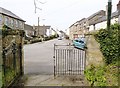
Looking out through the gates of St Newlyna's church, St. Newlyn East Cornwall
Looking along the road called "The Cross"
Image: © Derek Voller
Taken: 6 May 2016
0.18 miles