IMAGES TAKEN NEAR TO
Cargoll Road, NEWQUAY, TR8 5LB
Introduction
This page details the photographs taken nearby to Cargoll Road, TR8 5LB by members of the Geograph project.
The Geograph project started in 2005 with the aim of publishing, organising and preserving representative images for every square kilometre of Great Britain, Ireland and the Isle of Man.

There are currently over 7.5m images from over14,400 individuals and you can help contribute to the project by visiting https://www.geograph.org.uk
Image Map
Images are licensed for reuse under creativecommons.org/licenses/by-sa/2.0
Notes
- Clicking on the map will re-center to the selected point.
- The higher the marker number, the further away the image location is from the centre of the postcode.
Image Listing (37 Images Found)
Images are licensed for reuse under creativecommons.org/licenses/by-sa/2.0
Image
Details
Distance
1
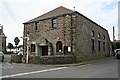
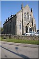
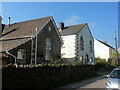
Methodist Church, St Newlyn East
The use of this building as a Methodist Church appears to be quite recent. A much larger building which has now been converted into private residences may have been the original church.
Image: © Tony Atkin
Taken: 10 Jun 2006
0.01 miles
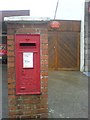
4
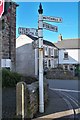
Direction Sign - Signpost by Station Road, St Newlyn East
Pyramid spear finial - one plastic arm; Cornwall CC iron spear by the UC road, in parish of St Newlyn East (Carrick District), Newlyn East Methodist Church, junction with Station Road, at back of footpath, against boundary wall.
Grade II listed.
List Entry Number: 1141455 https://historicengland.org.uk/listing/the-list/list-entry/1141455
Surveyed
Milestone Society National ID: CW_SW8256
Image: © Milestone Society
Taken: Unknown
0.08 miles
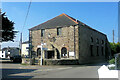
5
The Old Chapel, St Newlyn East
The Old Chapel in St Newlyn East appears to have been converted into residential accommodation.
Image: © Philip Halling
Taken: 17 Mar 2016
0.09 miles
7
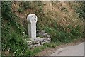
A Modern Roadside Cross
This is called the Neeham Cross and was erected on a site known to have been occupied in medieval times to commemorate the millennium in the year 2000. As this is Cornwall, the cross is, of course, in the Celtic style.
Image: © Tony Atkin
Taken: 3 Aug 2006
0.11 miles
8
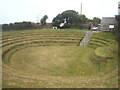
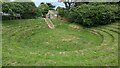
St Newlyn East preaching pit
Preaching Pits were places of outdoor worship in common use from the 18th century and throughout the Victorian period. This pit was originally an old stone quarry. Following the East Wheal Rose mining disaster of 1846 it was converted to a Preaching Pit as a memorial to those who had perished. Still in community use it has been refurbished with the aid of Lottery grant money.
Image: © Rod Allday
Taken: 7 Apr 2013
0.11 miles
9
Newlyn Preaching Pit and Storehouse
https://historicengland.org.uk/listing/the-list/list-entry/1141454?section=official-list-entry
Image: © Sandy Gerrard
Taken: 28 Jun 2024
0.11 miles
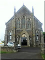
10
Bible Christian chapel, St Newlyn East
Image: © Paul Barnett
Taken: 3 Sep 2014
0.12 miles