
IMAGES TAKEN NEAR TO
Tremellyn Road, TR8 5FZ
Introduction
This page details the photographs taken nearby to Tremellyn Road, TR8 5FZ by members of the Geograph project.
The Geograph project started in 2005 with the aim of publishing, organising and preserving representative images for every square kilometre of Great Britain, Ireland and the Isle of Man.

There are currently over 7.5m images from over14,400 individuals and you can help contribute to the project by visiting https://www.geograph.org.uk
Image Map
Images are licensed for reuse under creativecommons.org/licenses/by-sa/2.0
Notes
- Clicking on the map will re-center to the selected point.
- The higher the marker number, the further away the image location is from the centre of the postcode.
Image Listing (23 Images Found)
Images are licensed for reuse under creativecommons.org/licenses/by-sa/2.0
Image
Details
Distance
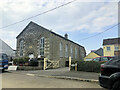
2

Former Wesleyan Chapel at Mitchell
Dated 1845 and now converted into residential use.
Image: © Rod Allday
Taken: 19 Oct 2008
0.04 miles
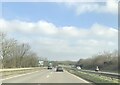
4
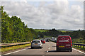
Cornwall : The A30
Looking along the A30 as it passes through Cornwall.
Image: © Lewis Clarke
Taken: 17 Jul 2015
0.07 miles
5
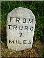
Old Milestone by the former A30 in Mitchell
Carved stone post by the UC road (was A30), in parish of ST NEWLYN EAST (CARRICK District), Mitchell, opposite Mitchell Farm in turning space on old A30, now bypassed, by the road, on North side of road. Truro stone, erected by the Truro turnpike trust in the 18th century.
Inscription reads:-
FROM
TRURO
7
MILES
Grade II listed.
List Entry Number: 1312510 https://historicengland.org.uk/listing/the-list/list-entry/1312510
Milestone Society National ID: CW_TOMI07.
Image: © Rosy Hanns
Taken: 17 May 2019
0.07 miles
6
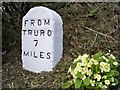
Old Milestone by the former A30 in Mitchell
Carved stone post by the UC road (was A30), in parish of ST NEWLYN EAST (CARRICK District), Mitchell, opposite Mitchell Farm in turning space on old A30, now by passed, by the road, on North side of road. Truro stone, erected by the Truro turnpike trust in the 18th century.
Inscription reads:-
FROM
TRURO
7
MILE
Grade II Listed. List Entry Number:1312510
https://historicengland.org.uk/listing/the-list/list-entry/1312510
Milestone Society National ID: CW_TOMI07.
Image: © Ian Thompson
Taken: 10 Dec 2017
0.07 miles
7

The Plume of Feathers at Mitchell
A very busy pub and popular hotel when the A30 passed through Mitchell but a bit quieter nowadays.
Image: © Rod Allday
Taken: 19 Oct 2008
0.07 miles
8
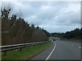
A30 north of Mitchell
The road runs on the side of a gentle slope, so the land drops away on the left and there is a slight slope up on the right, which screens the village from some road noise.
Image: © David Smith
Taken: 1 Feb 2013
0.07 miles
9
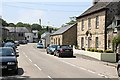
The Village of Mitchell
This is the main road through the village which would have been 'terrorised' by traffic before the building of the A30 bypass.
Image: © Tony Atkin
Taken: 10 Jun 2006
0.09 miles
10
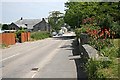
The Village of Mitchell
Looking along the road through the village to the east and the centre of the village. This scene is brightened up by the Red Hot Pokers growing in the garden in the foreground.
Image: © Tony Atkin
Taken: 10 Jun 2006
0.10 miles