IMAGES TAKEN NEAR TO
Cargy Close, NEWQUAY, TR8 5EJ
Introduction
This page details the photographs taken nearby to Cargy Close, TR8 5EJ by members of the Geograph project.
The Geograph project started in 2005 with the aim of publishing, organising and preserving representative images for every square kilometre of Great Britain, Ireland and the Isle of Man.

There are currently over 7.5m images from over14,400 individuals and you can help contribute to the project by visiting https://www.geograph.org.uk
Image Map
Images are licensed for reuse under creativecommons.org/licenses/by-sa/2.0
Notes
- Clicking on the map will re-center to the selected point.
- The higher the marker number, the further away the image location is from the centre of the postcode.
Image Listing (32 Images Found)
Images are licensed for reuse under creativecommons.org/licenses/by-sa/2.0
Image
Details
Distance
2
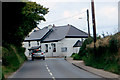
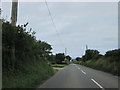
Approaching Cubert
The minor road which goes through the village of Cubert.
Image: © Robert Ashby
Taken: 17 Aug 2014
0.04 miles
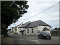
3
Cubert
The Anvil Inn and cottages, Cubert.
Image: © Pierre Terre
Taken: 25 Jul 2008
0.05 miles
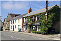
4
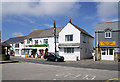
Cubert Post Office
Shops in the centre of Cubert.
Image: © Pierre Terre
Taken: 25 Jul 2008
0.05 miles
6
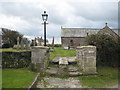
Lych gate at Cubert Church
It seems likely that the stone setts would have served as a form of cattle grid in the past, although the gaps between have now been filled with gravel. The stone plinth in the centre is a coffin rest to enable the pallbearers to negotiate safely the cattle grid.
Image: © Rod Allday
Taken: 19 Oct 2008
0.07 miles
8
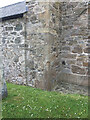
Section of St Cubert's Church, Cubert
OS Cut Mark on corner, more or less in the middle of photo
https://www.bench-marks.org.uk/bm82382
Image: © thejackrustles
Taken: 20 Jun 2021
0.07 miles
9
Old Wayside Cross
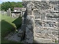
Ellenglaze Cross, a wayside cross - moved, with an old head & neck. Set in Cubert churchyard. Cubert parish. Langdon MC No. 27. Grade II Listed https://historicengland.org.uk/listing/the-list/list-entry/1141574. See also http://www.flickr.com/photos/ocifant/2836660583.
Milestone Society National ID: CWCA_CUB
Image: © L Nott
Taken: 15 Jun 2019
0.07 miles
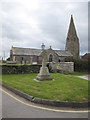
10
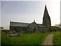
St Cubert's Church
The first church on this site would have been a small simple wooden building, probably with a thatched roof, then at the time of the Normans at the end of 11th C, it would have been replaced with a stone built church with a slate roof, and with a nave and tower. Standing at the foot of the steps at the north entrance and looking East toward the altar, we can try to imagine the third church built sometime between 1200 and 1300. Finally, in the fifteenth century, the South aisle was added with its fine colonnade of pillars, and the south transept rebuilt into the south wall. The spire was added somewhat later and is not typical of Cornish churches which mostly have square towers.
Image: © Rude Health
Taken: 9 May 2015
0.08 miles