IMAGES TAKEN NEAR TO
Summercourt, NEWQUAY, TR8 5BJ
Introduction
This page details the photographs taken nearby to TR8 5BJ by members of the Geograph project.
The Geograph project started in 2005 with the aim of publishing, organising and preserving representative images for every square kilometre of Great Britain, Ireland and the Isle of Man.

There are currently over 7.5m images from over14,400 individuals and you can help contribute to the project by visiting https://www.geograph.org.uk
Image Map
Images are licensed for reuse under creativecommons.org/licenses/by-sa/2.0
Notes
- Clicking on the map will re-center to the selected point.
- The higher the marker number, the further away the image location is from the centre of the postcode.
Image Listing (4 Images Found)
Images are licensed for reuse under creativecommons.org/licenses/by-sa/2.0
Image
Details
Distance
2
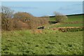
Farmland, St Enoder
A winding section of the A3058 is seen to the left of these fields.
Image: © Andrew Smith
Taken: 8 Apr 2022
0.11 miles
3
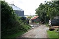
Encounter with a Main Road
This is dangerous! For a walker it is very dangerous. The road is barely wide enough for two lorries to pass and there is absolutely no verge to the road. I only had to walk a short stretch of this but three lorries had to stop for me and wait until there was no traffic in the opposite direction. Unfortunately once I exited the side road there was no alternative route.
Image: © Tony Atkin
Taken: 29 Aug 2006
0.17 miles