IMAGES TAKEN NEAR TO
Palm Way, NEWQUAY, TR8 4UR
Introduction
This page details the photographs taken nearby to Palm Way, TR8 4UR by members of the Geograph project.
The Geograph project started in 2005 with the aim of publishing, organising and preserving representative images for every square kilometre of Great Britain, Ireland and the Isle of Man.

There are currently over 7.5m images from over14,400 individuals and you can help contribute to the project by visiting https://www.geograph.org.uk
Image Map
Images are licensed for reuse under creativecommons.org/licenses/by-sa/2.0
Notes
- Clicking on the map will re-center to the selected point.
- The higher the marker number, the further away the image location is from the centre of the postcode.
Image Listing (12 Images Found)
Images are licensed for reuse under creativecommons.org/licenses/by-sa/2.0
Image
Details
Distance
1
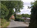
Lane through Trebarber
The lane through the tiny hamlet, with buildings at Trebarber Farm visible ahead where the lane bends left.
Image: © Derek Harper
Taken: 14 Jul 2010
0.08 miles
3
Lane near Trebarber
A bright freshly-harvested field contrasts with the shadowy lane, immediately west of the hamlet.
Image: © Derek Harper
Taken: 14 Jul 2010
0.11 miles
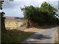
4
Field near Trebarber
A view over the gate shown in Image The field drops away into the Porth valley; Image is just round to the left.
Image: © Derek Harper
Taken: 14 Jul 2010
0.12 miles
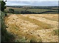
5
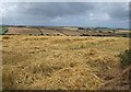
Harvested field, Trebarber
Another view across Image In the background, in the Porth valley, can be seen the roofs of houses at Trewassick.
Image: © Derek Harper
Taken: 14 Jul 2010
0.14 miles
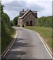
6
Lane near Trebarber
The lane north of the A3059 at Trebarber passes a cottage and a water tank. Image was taken from a bend in the lane just past the water tank.
Image: © Derek Harper
Taken: 14 Jul 2010
0.15 miles
7
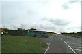
The road from St Mawgan airfield to the A3059
Image: © David Long
Taken: 9 May 2006
0.15 miles
8
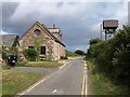
Cottage, Trebarber
The cottage is shown from the other direction in Image This was taken from beside the water tank.
Image: © Derek Harper
Taken: 14 Jul 2010
0.16 miles
9
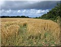
Barley near Trebarber
A field on the other side of the lane, and hence across a gridline, from Image
Image: © Derek Harper
Taken: 14 Jul 2010
0.22 miles
10
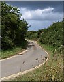
Lane near St Mawgan
The stretch of lane on the other side of the hedge seen on the right of Image Yellow lines because of the proximity to the airport.
Image: © Derek Harper
Taken: 14 Jul 2010
0.23 miles