IMAGES TAKEN NEAR TO
White Cross, NEWQUAY, TR8 4LW
Introduction
This page details the photographs taken nearby to TR8 4LW by members of the Geograph project.
The Geograph project started in 2005 with the aim of publishing, organising and preserving representative images for every square kilometre of Great Britain, Ireland and the Isle of Man.

There are currently over 7.5m images from over14,400 individuals and you can help contribute to the project by visiting https://www.geograph.org.uk
Image Map
Images are licensed for reuse under creativecommons.org/licenses/by-sa/2.0
Notes
- Clicking on the map will re-center to the selected point.
- The higher the marker number, the further away the image location is from the centre of the postcode.
Image Listing (6 Images Found)
Images are licensed for reuse under creativecommons.org/licenses/by-sa/2.0
Image
Details
Distance
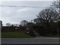
3
Restormel : The A392
The A392 in Restormel near White Cross. Some people are counting cars near the road junction.
Image: © Lewis Clarke
Taken: 15 Sep 2011
0.08 miles
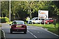
4
White Cross and a holiday camp
White Acres is a large holiday camp with lodges and static caravans. Most of the accommodation is on the right of the road, but there are about a dozen units in a plot on the left. The picture shows one of the entrances
Image: © David Smith
Taken: 8 Mar 2012
0.10 miles
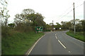
5
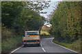
Colan : A392
The A392 heading through the Colan parish.
Image: © Lewis Clarke
Taken: 22 Oct 2019
0.12 miles
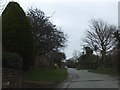
6
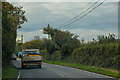
St Columb Major : A392
The A392 heading through the St Columb Major parish.
Image: © Lewis Clarke
Taken: 22 Oct 2019
0.18 miles