IMAGES TAKEN NEAR TO
Nanswhyden, NEWQUAY, TR8 4HT
Introduction
This page details the photographs taken nearby to TR8 4HT by members of the Geograph project.
The Geograph project started in 2005 with the aim of publishing, organising and preserving representative images for every square kilometre of Great Britain, Ireland and the Isle of Man.

There are currently over 7.5m images from over14,400 individuals and you can help contribute to the project by visiting https://www.geograph.org.uk
Image Map
Images are licensed for reuse under creativecommons.org/licenses/by-sa/2.0
Notes
- Clicking on the map will re-center to the selected point.
- The higher the marker number, the further away the image location is from the centre of the postcode.
Image Listing (2 Images Found)
Images are licensed for reuse under creativecommons.org/licenses/by-sa/2.0
Image
Details
Distance
1
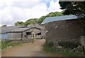
Nanswhyden
From the point where the public road ends, and combined footpaths 415/45/1 and 415/71/1 progress (unwaymarked) through the farmyard.
Image: © Derek Harper
Taken: 14 Jul 2010
0.01 miles
2
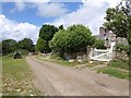
At Nanswydhen
The public road from Trevithick ends here, but paths continue. Nanswydhen is the site of an C18 mansion destroyed by fire in the early C19. The railings and wall are listed http://www.britishlistedbuildings.co.uk/en-71169-wall-with-railings-and-gateway-about-10-m . On the right is a glimpse of the farmhouse http://www.britishlistedbuildings.co.uk/en-71168-nanswydhen-farmhouse-with-wall-about-50-m .
Image: © Derek Harper
Taken: 14 Jul 2010
0.04 miles