IMAGES TAKEN NEAR TO
Trevithick Downs, NEWQUAY, TR8 4DY
Introduction
This page details the photographs taken nearby to TR8 4DY by members of the Geograph project.
The Geograph project started in 2005 with the aim of publishing, organising and preserving representative images for every square kilometre of Great Britain, Ireland and the Isle of Man.

There are currently over 7.5m images from over14,400 individuals and you can help contribute to the project by visiting https://www.geograph.org.uk
Image Map
Images are licensed for reuse under creativecommons.org/licenses/by-sa/2.0
Notes
- Clicking on the map will re-center to the selected point.
- The higher the marker number, the further away the image location is from the centre of the postcode.
Image Listing (8 Images Found)
Images are licensed for reuse under creativecommons.org/licenses/by-sa/2.0
Image
Details
Distance
1
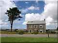
Trevithick Downs
An isolated house on the A3059 between St Columb Major and St Columb Minor, near the southeastern corner of St Mawgan Airport, with a cedar tree beside it..
Image: © Derek Harper
Taken: 14 Jul 2010
0.03 miles
2
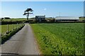
Road and farmland, St Columb Major
The minor road at Trevithick Downs has acquired a fence on one side. The house has been joined by an air ambulance station.
Image: © Andrew Smith
Taken: 26 Apr 2022
0.05 miles
3
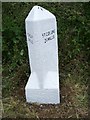
Old Milestone by the A3059, Trevithick Downs
Carved stone post by the A3059, in parish of ST COLUMB MAJOR (RESTORMEL District), opposite Trevithick Downs B+B, on wide verge, on South side of road. Erected by the Local Highways Board in the 19th century.
Inscription reads:-
: NEWQUAY / 5 MILES : : ST COLUMB / 2¼ MILES :
Carved benchmark on top right.
Grade II Listed. List Entry Number: 1137857
https://historicengland.org.uk/listing/the-list/list-entry/1137857
Milestone Society National ID: CW_NQSC05.
Image: © Ian Thompson
Taken: 10 Dec 2017
0.05 miles
4
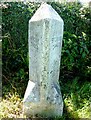
Old Milestone by the A3059, Trevithick Downs
Carved stone post by the A3059, in parish of ST COLUMB MAJOR (RESTORMEL District), opposite Trevithick Downs B+B, on wide verge, on South side of road. Erected by the Local Highways Board in the 19th century.
Inscription reads:-
: NEWQUAY / 5 MILES : : ST COLUMB / 2¼ MILES :
Carved benchmark on right side face.
Grade II listed.
List Entry Number: 1137857 https://historicengland.org.uk/listing/the-list/list-entry/1137857
Milestone Society National ID: CW_NQSC05.
Image: © Rosy Hanns
Taken: 12 May 2019
0.05 miles
5

Potato flowers, Trevithick Downs
Bright magenta and orange potato flowers by the unfenced lane from Trevithick Downs to the hamlet of Trevithick.
Image: © Derek Harper
Taken: 14 Jul 2010
0.07 miles
6
Trevithick Downs
Image: © Derek Harper
Taken: 14 Jul 2010
0.07 miles
7

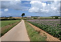
Potato field, Trevithick Downs
Image placed in a bit more context. The A3059 is behind the hedge on the left.
Image: © Derek Harper
Taken: 14 Jul 2010
0.11 miles
8
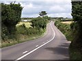
A3059 approaching Trevithick Downs
The main road between St Columb Minor and St Columb Major reaches the edge of the square.
Image: © Derek Harper
Taken: 14 Jul 2010
0.15 miles