IMAGES TAKEN NEAR TO
Penpont, NEWQUAY, TR8 4DT
Introduction
This page details the photographs taken nearby to Penpont, TR8 4DT by members of the Geograph project.
The Geograph project started in 2005 with the aim of publishing, organising and preserving representative images for every square kilometre of Great Britain, Ireland and the Isle of Man.

There are currently over 7.5m images from over14,400 individuals and you can help contribute to the project by visiting https://www.geograph.org.uk
Image Map
Images are licensed for reuse under creativecommons.org/licenses/by-sa/2.0
Notes
- Clicking on the map will re-center to the selected point.
- The higher the marker number, the further away the image location is from the centre of the postcode.
Image Listing (38 Images Found)
Images are licensed for reuse under creativecommons.org/licenses/by-sa/2.0
Image
Details
Distance
1
View from the top deck
The 556 Newquay-Padstow service is operated partly by a double-decker bus - hair-raising on the narrow, confined country roads at the best of times... then the width was further reduced by this scaffolding - a Health & Safety measure...
Image: © David Long
Taken: 11 May 2006
0.01 miles
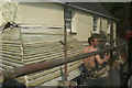
2
St Mawgan, North of the River
A hodge-podge of houses line the road as it begins to climb the valley side.
Image: © Tony Atkin
Taken: 8 May 2011
0.02 miles

5

St Mawgan - Fresh Grapes with my Cheese?
A vinery within a cafeteria.
Image: © Richard Hoare
Taken: 27 Jun 2008
0.06 miles
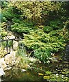
7

St Mawgan: village store and home delivery ststem
The village of St Mawgan is well known as the site of a Japanese garden and bonsai nursery (see also SW8766)
Image: © C P Smith
Taken: 27 Sep 2008
0.06 miles
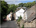
8

St Mawgan Playing Field
Panorama shot of St Mawgan Playing Fields.
Image: © Ian Knight
Taken: 10 Jul 2014
0.06 miles
9
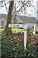
Direction Sign - Signpost by St Mawgan's churchyard
Missing cone finial - Two arms and finial missing; by the UC road, in parish of Mawgan in Pydar (Restormel District), T-junction beside St Mawgan churchyard in village centre, set into wall of churchyard.
Grade II listed.
List Entry Number: 1144133 https://historicengland.org.uk/listing/the-list/list-entry/1144133
Surveyed
Milestone Society National ID: CW_SW8765
Image: © Milestone Society
Taken: Unknown
0.07 miles
10

Old Wayside Cross - moved to St Mawgan churchyard
Mawgan Cross, old head and neck, Langdon MC No. 68 by the churchyard path, in parish of Mawgan in Pydar (Restormel District), in churchyard, between path and wall of church tower, among small memorials.
Grade II* listed.
List Entry Number: 1144129 https://historicengland.org.uk/listing/the-list/list-entry/1144129
Surveyed
Milestone Society National ID: CWRE_MAW02
Image: © Alan Rosevear
Taken: 17 Sep 2013
0.09 miles